You are here: Home > Network List > TA - USArray Transportable Network (new EarthScope stations) Stations List
> Station P18K Big Mountain, AK, USA > Earthquake Result Viewer
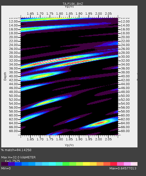
P18K Big Mountain, AK, USA - Earthquake Result Viewer
| Earthquake location: |
Mindanao, Philippines |
| Earthquake latitude/longitude: |
7.1/125.3 |
| Earthquake time(UTC): |
2019/10/31 (304) 01:11:20 GMT |
| Earthquake Depth: |
22 km |
| Earthquake Magnitude: |
6.8 Mi |
| Earthquake Catalog/Contributor: |
NEIC PDE/at |
|
| Network: |
TA USArray Transportable Network (new EarthScope stations) |
| Station: |
P18K Big Mountain, AK, USA |
| Lat/Lon: |
59.39 N/155.23 W |
| Elevation: |
680 m |
|
| Distance: |
78.6 deg |
| Az: |
30.882 deg |
| Baz: |
264.556 deg |
| Ray Param: |
0.049533773 |
| Estimated Moho Depth: |
32.0 km |
| Estimated Crust Vp/Vs: |
1.75 |
| Assumed Crust Vp: |
6.438 km/s |
| Estimated Crust Vs: |
3.674 km/s |
| Estimated Crust Poisson's Ratio: |
0.26 |
|
| Radial Match: |
94.14258 % |
| Radial Bump: |
400 |
| Transverse Match: |
83.66265 % |
| Transverse Bump: |
400 |
| SOD ConfigId: |
19951751 |
| Insert Time: |
2019-11-14 01:22:43.335 +0000 |
| GWidth: |
2.5 |
| Max Bumps: |
400 |
| Tol: |
0.001 |
|

Signal To Noise
| Channel | StoN | STA | LTA |
| TA:P18K: :BHZ:20191031T01:22:48.400024Z | 10.88766 | 1.3228907E-6 | 1.2150367E-7 |
| TA:P18K: :BHN:20191031T01:22:48.400024Z | 0.913595 | 1.5261853E-7 | 1.6705272E-7 |
| TA:P18K: :BHE:20191031T01:22:48.400024Z | 2.8319788 | 3.8496734E-7 | 1.359358E-7 |
| Arrivals |
| Ps | 3.9 SECOND |
| PpPs | 13 SECOND |
| PsPs/PpSs | 17 SECOND |


