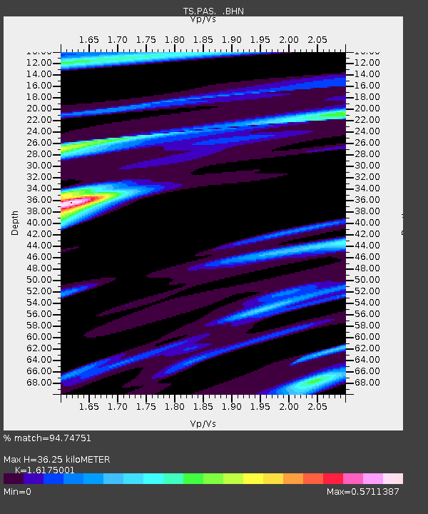
PAS Pasadena, California, USA - Earthquake Result Viewer
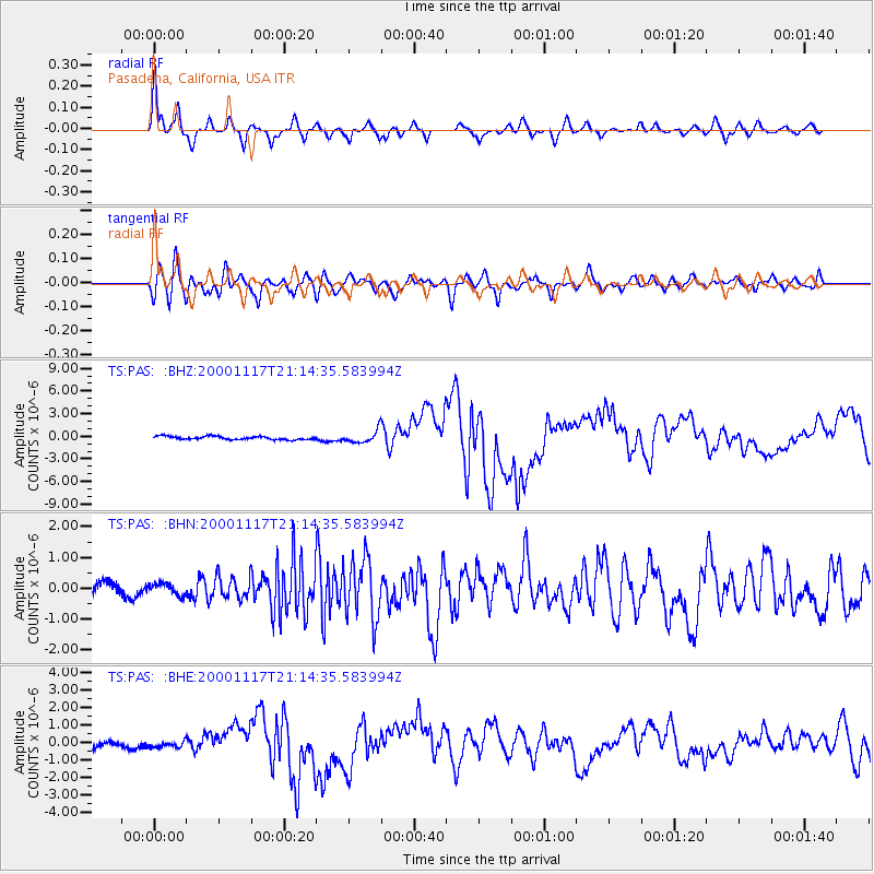
Earthquake location: New Britain Region, P.N.G.
Earthquake latitude/longitude: -5.5/151.8
Earthquake time(UTC): 2000/11/17 (322) 21:01:56 GMT
Earthquake Depth: 33 km
Earthquake Magnitude: 6.2 MB, 8.0 MS, 7.6 MW, 6.9 ME
Earthquake Catalog/Contributor: WHDF/NEIC
Network: TS TERRAscope (Southern California Seismic Network)
Station: PAS Pasadena, California, USA
Lat/Lon: 34.15 N/118.17 W
Elevation: 295 m
Distance: 93.1 deg
Az: 56.154 deg
Baz: 265.494 deg
Ray Param: 0.041319337
Estimated Moho Depth: 36.25 km
Estimated Crust Vp/Vs: 1.62
Assumed Crust Vp: 6.1 km/s
Estimated Crust Vs: 3.771 km/s
Estimated Crust Poisson's Ratio: 0.19
Radial Match: 94.74751 %
Radial Bump: 357
Transverse Match: 84.94933 %
Transverse Bump: 400
SOD ConfigId: 3744
Insert Time: 2010-02-26 14:32:27.240 +0000
GWidth: 2.5
Max Bumps: 400
Tol: 0.001

Signal To Noise

ChannelStoNSTALTA
TS:PAS: :BHN:20001117T21:14:35.583994Z0.63418971.8778006E-72.9609447E-7
TS:PAS: :BHE:20001117T21:14:35.583994Z0.92805641.6352745E-71.7620421E-7
TS:PAS: :BHZ:20001117T21:14:35.583994Z3.68157748.164482E-72.2176587E-7
Arrivals
Ps3.7 SECOND
PpPs15 SECOND
PsPs/PpSs19 SECOND