You are here: Home > Network List > GT - Global Telemetered Seismograph Network (USAF/USGS) Stations List
> Station LPAZ La Paz , Bolivia > Earthquake Result Viewer
LPAZ La Paz , Bolivia - Earthquake Result Viewer

| Earthquake location: |
South Sandwich Islands Region |
| Earthquake latitude/longitude: |
-55.7/-26.3 |
| Earthquake time(UTC): |
2019/11/02 (306) 18:08:41 GMT |
| Earthquake Depth: |
10 km |
| Earthquake Magnitude: |
6.1 Mww |
| Earthquake Catalog/Contributor: |
NEIC PDE/us |
|
| Network: |
GT Global Telemetered Seismograph Network (USAF/USGS) |
| Station: |
LPAZ La Paz , Bolivia |
| Lat/Lon: |
16.17 S/68.08 W |
| Elevation: |
4817 m |
|
| Distance: |
50.7 deg |
| Az: |
304.129 deg |
| Baz: |
150.806 deg |
| Ray Param: |
0.06790743 |
| Estimated Moho Depth: |
62.75 km |
| Estimated Crust Vp/Vs: |
1.72 |
| Assumed Crust Vp: |
6.454 km/s |
| Estimated Crust Vs: |
3.752 km/s |
| Estimated Crust Poisson's Ratio: |
0.24 |
|
| Radial Match: |
93.19619 % |
| Radial Bump: |
400 |
| Transverse Match: |
88.54759 % |
| Transverse Bump: |
400 |
| SOD ConfigId: |
19951751 |
| Insert Time: |
2019-11-16 18:12:30.241 +0000 |
| GWidth: |
2.5 |
| Max Bumps: |
400 |
| Tol: |
0.001 |
|
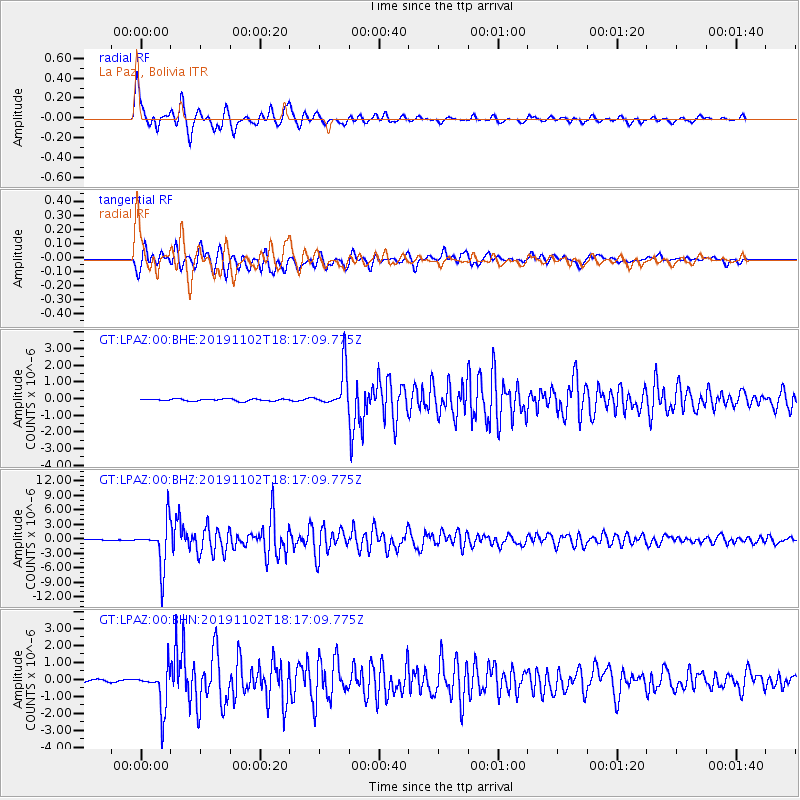
Signal To Noise
| Channel | StoN | STA | LTA |
| GT:LPAZ:00:BHZ:20191102T18:17:09.775Z | 46.08347 | 4.5845577E-6 | 9.948378E-8 |
| GT:LPAZ:00:BHN:20191102T18:17:09.775Z | 17.491503 | 1.2123018E-6 | 6.930804E-8 |
| GT:LPAZ:00:BHE:20191102T18:17:09.775Z | 22.810997 | 1.4212134E-6 | 6.230387E-8 |
| Arrivals |
| Ps | 7.4 SECOND |
| PpPs | 25 SECOND |
| PsPs/PpSs | 32 SECOND |


