You are here: Home > Network List > ON - RSIS-Rede Sismografica do Sul e Sudeste Observatorio Nacional, Brazil Stations List
> Station GUA01 "OBSN: [GUA01] Guaratinga, BA" > Earthquake Result Viewer
GUA01 "OBSN: [GUA01] Guaratinga, BA" - Earthquake Result Viewer
| Earthquake location: |
South Sandwich Islands Region |
| Earthquake latitude/longitude: |
-55.7/-26.3 |
| Earthquake time(UTC): |
2019/11/02 (306) 18:08:41 GMT |
| Earthquake Depth: |
10 km |
| Earthquake Magnitude: |
6.1 Mww |
| Earthquake Catalog/Contributor: |
NEIC PDE/us |
|
| Network: |
ON RSIS-Rede Sismografica do Sul e Sudeste Observatorio Nacional, Brazil |
| Station: |
GUA01 "OBSN: [GUA01] Guaratinga, BA" |
| Lat/Lon: |
16.58 S/39.81 W |
| Elevation: |
198 m |
|
| Distance: |
40.4 deg |
| Az: |
339.78 deg |
| Baz: |
168.224 deg |
| Ray Param: |
0.07443376 |
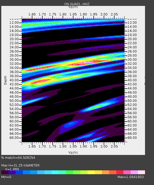
| Estimated Moho Depth: |
31.25 km |
| Estimated Crust Vp/Vs: |
1.89 |
| Assumed Crust Vp: |
6.391 km/s |
| Estimated Crust Vs: |
3.372 km/s |
| Estimated Crust Poisson's Ratio: |
0.31 |
|
| Radial Match: |
84.509254 % |
| Radial Bump: |
315 |
| Transverse Match: |
68.095634 % |
| Transverse Bump: |
400 |
| SOD ConfigId: |
19951751 |
| Insert Time: |
2019-11-16 18:12:55.583 +0000 |
| GWidth: |
2.5 |
| Max Bumps: |
400 |
| Tol: |
0.001 |
|

Signal To Noise
| Channel | StoN | STA | LTA |
| ON:GUA01: :HHZ:20191102T18:15:49.078009Z | 12.859357 | 3.944906E-6 | 3.067732E-7 |
| ON:GUA01: :HHN:20191102T18:15:49.078009Z | 15.141752 | 2.0483744E-6 | 1.3527989E-7 |
| ON:GUA01: :HHE:20191102T18:15:49.078009Z | 3.3388064 | 7.314263E-7 | 2.1906821E-7 |
| Arrivals |
| Ps | 4.7 SECOND |
| PpPs | 13 SECOND |
| PsPs/PpSs | 18 SECOND |


