You are here: Home > Network List > US - United States National Seismic Network Stations List
> Station BOZ Bozeman, Montana, USA > Earthquake Result Viewer
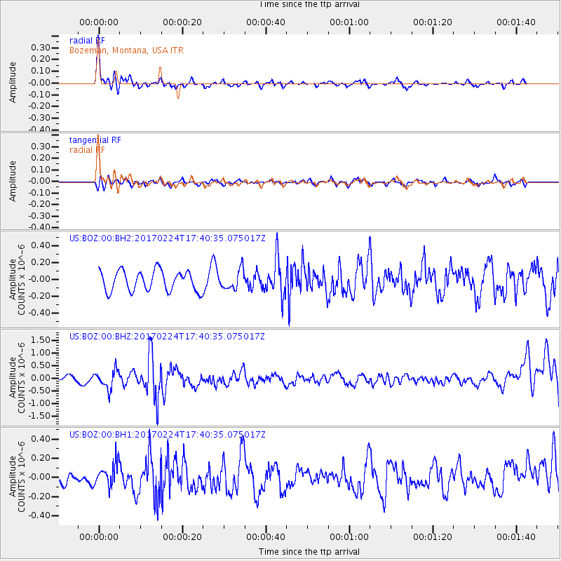
BOZ Bozeman, Montana, USA - Earthquake Result Viewer
*The percent match for this event was below the threshold and hence no stack was calculated.
| Earthquake location: |
South Of Fiji Islands |
| Earthquake latitude/longitude: |
-23.2/-178.8 |
| Earthquake time(UTC): |
2017/02/24 (055) 17:28:44 GMT |
| Earthquake Depth: |
415 km |
| Earthquake Magnitude: |
6.9 mww |
| Earthquake Catalog/Contributor: |
NEIC PDE/us |
|
| Network: |
US United States National Seismic Network |
| Station: |
BOZ Bozeman, Montana, USA |
| Lat/Lon: |
45.65 N/111.63 W |
| Elevation: |
1589 m |
|
| Distance: |
91.7 deg |
| Az: |
40.314 deg |
| Baz: |
238.029 deg |
| Ray Param: |
$rayparam |
*The percent match for this event was below the threshold and hence was not used in the summary stack. |
|
| Radial Match: |
69.20754 % |
| Radial Bump: |
312 |
| Transverse Match: |
41.58839 % |
| Transverse Bump: |
391 |
| SOD ConfigId: |
1992691 |
| Insert Time: |
2017-03-10 17:31:29.063 +0000 |
| GWidth: |
2.5 |
| Max Bumps: |
400 |
| Tol: |
0.001 |
|
Signal To Noise
| Channel | StoN | STA | LTA |
| US:BOZ:00:BHZ:20170224T17:40:35.075017Z | 3.3356194 | 3.687019E-7 | 1.10534764E-7 |
| US:BOZ:00:BH1:20170224T17:40:35.075017Z | 1.743426 | 1.2180557E-7 | 6.9865635E-8 |
| US:BOZ:00:BH2:20170224T17:40:35.075017Z | 0.9889754 | 1.18263515E-7 | 1.1958186E-7 |
| Arrivals |
| Ps | |
| PpPs | |
| PsPs/PpSs | |


