You are here: Home > Network List > WI - West Indies IPGP Network Stations List
> Station BIM Morne Bigot, Anses d'Arlets, Martinique > Earthquake Result Viewer
BIM Morne Bigot, Anses d'Arlets, Martinique - Earthquake Result Viewer
| Earthquake location: |
South Sandwich Islands Region |
| Earthquake latitude/longitude: |
-55.7/-26.3 |
| Earthquake time(UTC): |
2019/11/02 (306) 18:08:41 GMT |
| Earthquake Depth: |
10 km |
| Earthquake Magnitude: |
6.1 Mww |
| Earthquake Catalog/Contributor: |
NEIC PDE/us |
|
| Network: |
WI West Indies IPGP Network |
| Station: |
BIM Morne Bigot, Anses d'Arlets, Martinique |
| Lat/Lon: |
14.52 N/61.07 W |
| Elevation: |
391 m |
|
| Distance: |
75.8 deg |
| Az: |
325.277 deg |
| Baz: |
160.547 deg |
| Ray Param: |
0.051418737 |
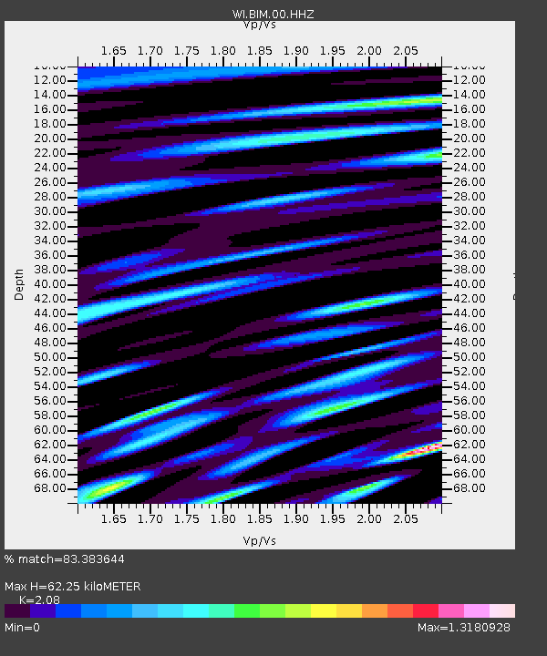
| Estimated Moho Depth: |
62.25 km |
| Estimated Crust Vp/Vs: |
2.08 |
| Assumed Crust Vp: |
5.88 km/s |
| Estimated Crust Vs: |
2.827 km/s |
| Estimated Crust Poisson's Ratio: |
0.35 |
|
| Radial Match: |
83.383644 % |
| Radial Bump: |
400 |
| Transverse Match: |
79.322586 % |
| Transverse Bump: |
400 |
| SOD ConfigId: |
19951751 |
| Insert Time: |
2019-11-16 18:13:53.025 +0000 |
| GWidth: |
2.5 |
| Max Bumps: |
400 |
| Tol: |
0.001 |
|

Signal To Noise
| Channel | StoN | STA | LTA |
| WI:BIM:00:HHZ:20191102T18:19:56.750006Z | 9.650313 | 2.9211008E-6 | 3.0269493E-7 |
| WI:BIM:00:HHN:20191102T18:19:56.750006Z | 2.6729004 | 1.1661706E-6 | 4.362941E-7 |
| WI:BIM:00:HHE:20191102T18:19:56.750006Z | 1.5746607 | 7.572187E-7 | 4.8087736E-7 |
| Arrivals |
| Ps | 12 SECOND |
| PpPs | 32 SECOND |
| PsPs/PpSs | 44 SECOND |


