You are here: Home > Network List > WI - West Indies IPGP Network Stations List
> Station MPOM Morne Pois, Sainte-Anne, Martinique > Earthquake Result Viewer
MPOM Morne Pois, Sainte-Anne, Martinique - Earthquake Result Viewer
| Earthquake location: |
South Sandwich Islands Region |
| Earthquake latitude/longitude: |
-55.7/-26.3 |
| Earthquake time(UTC): |
2019/11/02 (306) 18:08:41 GMT |
| Earthquake Depth: |
10 km |
| Earthquake Magnitude: |
6.1 Mww |
| Earthquake Catalog/Contributor: |
NEIC PDE/us |
|
| Network: |
WI West Indies IPGP Network |
| Station: |
MPOM Morne Pois, Sainte-Anne, Martinique |
| Lat/Lon: |
14.45 N/60.86 W |
| Elevation: |
50 m |
|
| Distance: |
75.7 deg |
| Az: |
325.448 deg |
| Baz: |
160.641 deg |
| Ray Param: |
0.05150881 |
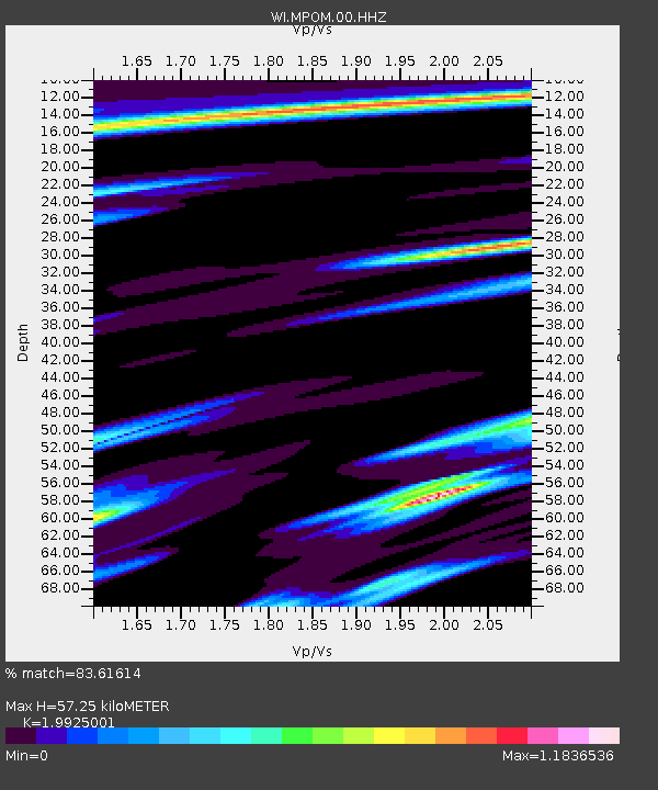
| Estimated Moho Depth: |
57.25 km |
| Estimated Crust Vp/Vs: |
1.99 |
| Assumed Crust Vp: |
5.88 km/s |
| Estimated Crust Vs: |
2.951 km/s |
| Estimated Crust Poisson's Ratio: |
0.33 |
|
| Radial Match: |
83.61614 % |
| Radial Bump: |
400 |
| Transverse Match: |
67.864655 % |
| Transverse Bump: |
400 |
| SOD ConfigId: |
19951751 |
| Insert Time: |
2019-11-16 18:13:55.981 +0000 |
| GWidth: |
2.5 |
| Max Bumps: |
400 |
| Tol: |
0.001 |
|

Signal To Noise
| Channel | StoN | STA | LTA |
| WI:MPOM:00:HHZ:20191102T18:19:55.989996Z | 5.842673 | 2.9243806E-6 | 5.00521E-7 |
| WI:MPOM:00:HHN:20191102T18:19:55.989996Z | 3.422299 | 1.2648325E-6 | 3.6958562E-7 |
| WI:MPOM:00:HHE:20191102T18:19:55.989996Z | 1.2417831 | 7.205452E-7 | 5.802504E-7 |
| Arrivals |
| Ps | 9.9 SECOND |
| PpPs | 28 SECOND |
| PsPs/PpSs | 38 SECOND |


