You are here: Home > Network List > TA - USArray Transportable Network (new EarthScope stations) Stations List
> Station V13A Grand Canyon West Ranch, Meadview, AZ, USA > Earthquake Result Viewer
V13A Grand Canyon West Ranch, Meadview, AZ, USA - Earthquake Result Viewer
| Earthquake location: |
Fiji Islands Region |
| Earthquake latitude/longitude: |
-17.3/-177.3 |
| Earthquake time(UTC): |
2008/07/19 (201) 22:39:52 GMT |
| Earthquake Depth: |
391 km |
| Earthquake Magnitude: |
5.9 MB, 6.4 MW, 6.4 MW |
| Earthquake Catalog/Contributor: |
WHDF/NEIC |
|
| Network: |
TA USArray Transportable Network (new EarthScope stations) |
| Station: |
V13A Grand Canyon West Ranch, Meadview, AZ, USA |
| Lat/Lon: |
35.85 N/113.98 W |
| Elevation: |
1402 m |
|
| Distance: |
79.9 deg |
| Az: |
47.511 deg |
| Baz: |
240.109 deg |
| Ray Param: |
0.047571152 |
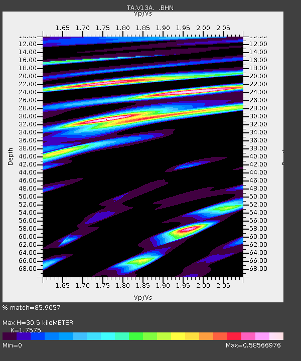
| Estimated Moho Depth: |
30.5 km |
| Estimated Crust Vp/Vs: |
1.76 |
| Assumed Crust Vp: |
6.276 km/s |
| Estimated Crust Vs: |
3.571 km/s |
| Estimated Crust Poisson's Ratio: |
0.26 |
|
| Radial Match: |
85.9057 % |
| Radial Bump: |
400 |
| Transverse Match: |
67.46104 % |
| Transverse Bump: |
400 |
| SOD ConfigId: |
2504 |
| Insert Time: |
2010-03-07 05:24:30.411 +0000 |
| GWidth: |
2.5 |
| Max Bumps: |
400 |
| Tol: |
0.001 |
|
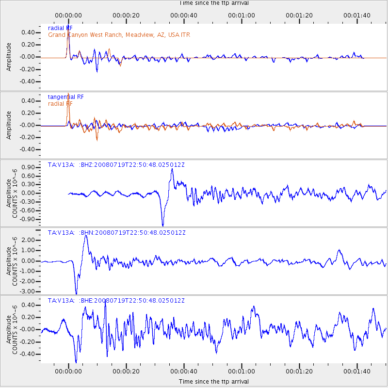
Signal To Noise
| Channel | StoN | STA | LTA |
| TA:V13A: :BHN:20080719T22:50:48.025012Z | 17.341639 | 1.2511745E-6 | 7.214857E-8 |
| TA:V13A: :BHE:20080719T22:50:48.025012Z | 3.0750275 | 2.3850177E-7 | 7.7560856E-8 |
| TA:V13A: :BHZ:20080719T22:50:48.025012Z | 9.3305235 | 4.4913736E-7 | 4.813635E-8 |
| Arrivals |
| Ps | 3.8 SECOND |
| PpPs | 13 SECOND |
| PsPs/PpSs | 17 SECOND |


