You are here: Home > Network List > TA - USArray Transportable Network (new EarthScope stations) Stations List
> Station V13A Grand Canyon West Ranch, Meadview, AZ, USA > Earthquake Result Viewer
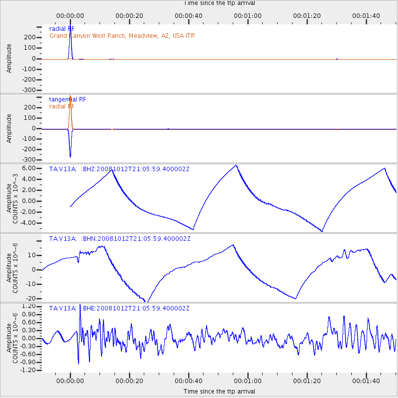
V13A Grand Canyon West Ranch, Meadview, AZ, USA - Earthquake Result Viewer
| Earthquake location: |
Southern Bolivia |
| Earthquake latitude/longitude: |
-20.1/-65.0 |
| Earthquake time(UTC): |
2008/10/12 (286) 20:55:41 GMT |
| Earthquake Depth: |
353 km |
| Earthquake Magnitude: |
6.0 MB, 6.2 MW, 6.2 MW |
| Earthquake Catalog/Contributor: |
WHDF/NEIC |
|
| Network: |
TA USArray Transportable Network (new EarthScope stations) |
| Station: |
V13A Grand Canyon West Ranch, Meadview, AZ, USA |
| Lat/Lon: |
35.85 N/113.98 W |
| Elevation: |
1402 m |
|
| Distance: |
72.5 deg |
| Az: |
319.975 deg |
| Baz: |
131.935 deg |
| Ray Param: |
0.052602805 |
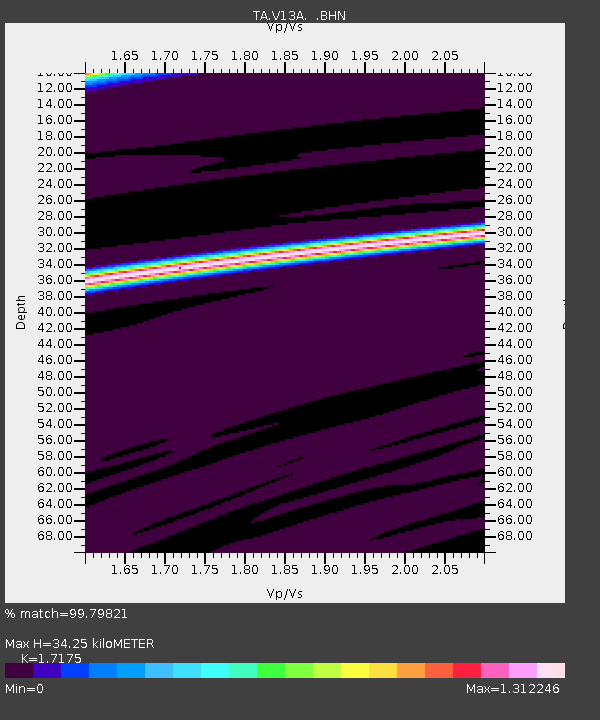
| Estimated Moho Depth: |
34.25 km |
| Estimated Crust Vp/Vs: |
1.72 |
| Assumed Crust Vp: |
6.276 km/s |
| Estimated Crust Vs: |
3.654 km/s |
| Estimated Crust Poisson's Ratio: |
0.24 |
|
| Radial Match: |
99.79821 % |
| Radial Bump: |
9 |
| Transverse Match: |
99.79514 % |
| Transverse Bump: |
8 |
| SOD ConfigId: |
2556 |
| Insert Time: |
2010-03-07 05:24:38.924 +0000 |
| GWidth: |
2.5 |
| Max Bumps: |
400 |
| Tol: |
0.001 |
|
Signal To Noise
| Channel | StoN | STA | LTA |
| TA:V13A: :BHN:20081012T21:05:59.400002Z | 2.3218715 | 1.6303718E-5 | 7.0218007E-6 |
| TA:V13A: :BHE:20081012T21:05:59.400002Z | 2.7286432 | 4.0545896E-7 | 1.4859361E-7 |
| TA:V13A: :BHZ:20081012T21:05:59.400002Z | 2.2806323 | 0.004807016 | 0.002107756 |
| Arrivals |
| Ps | 4.0 SECOND |
| PpPs | 14 SECOND |
| PsPs/PpSs | 18 SECOND |


