You are here: Home > Network List > TA - USArray Transportable Network (new EarthScope stations) Stations List
> Station V13A Grand Canyon West Ranch, Meadview, AZ, USA > Earthquake Result Viewer
V13A Grand Canyon West Ranch, Meadview, AZ, USA - Earthquake Result Viewer
| Earthquake location: |
South Of Fiji Islands |
| Earthquake latitude/longitude: |
-26.0/-177.5 |
| Earthquake time(UTC): |
2007/12/09 (343) 07:28:20 GMT |
| Earthquake Depth: |
152 km |
| Earthquake Magnitude: |
7.0 MB, 7.8 MW, 7.7 MW |
| Earthquake Catalog/Contributor: |
WHDF/NEIC |
|
| Network: |
TA USArray Transportable Network (new EarthScope stations) |
| Station: |
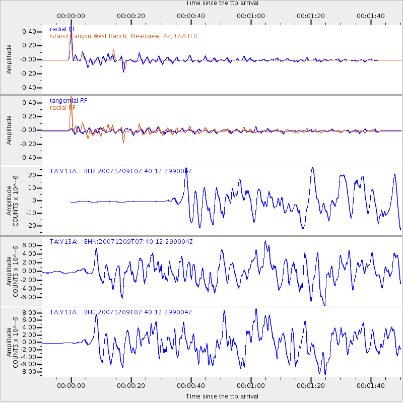
V13A Grand Canyon West Ranch, Meadview, AZ, USA |
| Lat/Lon: |
35.85 N/113.98 W |
| Elevation: |
1402 m |
|
| Distance: |
85.9 deg |
| Az: |
46.811 deg |
| Baz: |
233.873 deg |
| Ray Param: |
0.04410142 |
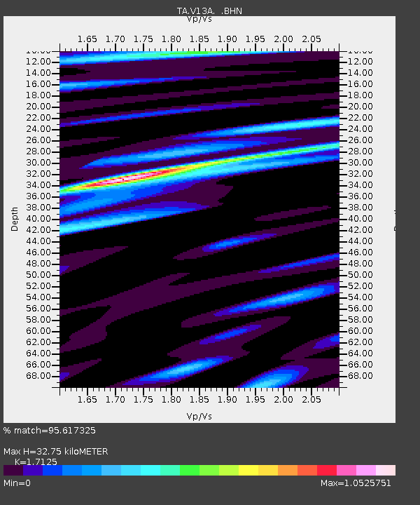
| Estimated Moho Depth: |
32.75 km |
| Estimated Crust Vp/Vs: |
1.71 |
| Assumed Crust Vp: |
6.276 km/s |
| Estimated Crust Vs: |
3.665 km/s |
| Estimated Crust Poisson's Ratio: |
0.24 |
|
| Radial Match: |
95.617325 % |
| Radial Bump: |
400 |
| Transverse Match: |
89.17666 % |
| Transverse Bump: |
400 |
| SOD ConfigId: |
2564 |
| Insert Time: |
2010-03-07 05:24:55.446 +0000 |
| GWidth: |
2.5 |
| Max Bumps: |
400 |
| Tol: |
0.001 |
|
Signal To Noise
| Channel | StoN | STA | LTA |
| TA:V13A: :BHN:20071209T07:40:12.299004Z | 3.9848082 | 4.0108478E-7 | 1.0065347E-7 |
| TA:V13A: :BHE:20071209T07:40:12.299004Z | 3.443641 | 3.8022898E-7 | 1.1041482E-7 |
| TA:V13A: :BHZ:20071209T07:40:12.299004Z | 4.306266 | 1.1627916E-6 | 2.7002318E-7 |
| Arrivals |
| Ps | 3.8 SECOND |
| PpPs | 14 SECOND |
| PsPs/PpSs | 18 SECOND |


