You are here: Home > Network List > US - United States National Seismic Network Stations List
> Station NEW Newport, Washington, USA > Earthquake Result Viewer
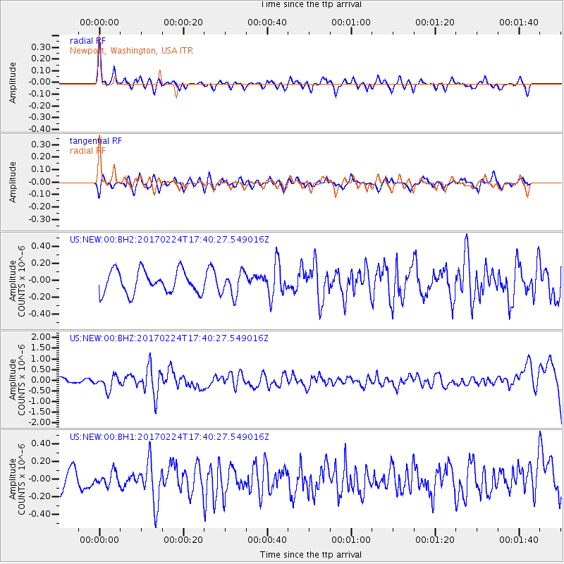
NEW Newport, Washington, USA - Earthquake Result Viewer
*The percent match for this event was below the threshold and hence no stack was calculated.
| Earthquake location: |
South Of Fiji Islands |
| Earthquake latitude/longitude: |
-23.2/-178.8 |
| Earthquake time(UTC): |
2017/02/24 (055) 17:28:44 GMT |
| Earthquake Depth: |
415 km |
| Earthquake Magnitude: |
6.9 mww |
| Earthquake Catalog/Contributor: |
NEIC PDE/us |
|
| Network: |
US United States National Seismic Network |
| Station: |
NEW Newport, Washington, USA |
| Lat/Lon: |
48.26 N/117.12 W |
| Elevation: |
760 m |
|
| Distance: |
90.0 deg |
| Az: |
36.044 deg |
| Baz: |
234.092 deg |
| Ray Param: |
$rayparam |
*The percent match for this event was below the threshold and hence was not used in the summary stack. |
|
| Radial Match: |
70.68566 % |
| Radial Bump: |
400 |
| Transverse Match: |
54.769215 % |
| Transverse Bump: |
400 |
| SOD ConfigId: |
1992691 |
| Insert Time: |
2017-03-10 17:31:48.845 +0000 |
| GWidth: |
2.5 |
| Max Bumps: |
400 |
| Tol: |
0.001 |
|
Signal To Noise
| Channel | StoN | STA | LTA |
| US:NEW:00:BHZ:20170224T17:40:27.549016Z | 2.5561192 | 3.3712797E-7 | 1.3189054E-7 |
| US:NEW:00:BH1:20170224T17:40:27.549016Z | 0.51404256 | 7.6374974E-8 | 1.4857714E-7 |
| US:NEW:00:BH2:20170224T17:40:27.549016Z | 1.0699427 | 1.4104153E-7 | 1.3182155E-7 |
| Arrivals |
| Ps | |
| PpPs | |
| PsPs/PpSs | |


