You are here: Home > Network List > TA - USArray Transportable Network (new EarthScope stations) Stations List
> Station V13A Grand Canyon West Ranch, Meadview, AZ, USA > Earthquake Result Viewer
V13A Grand Canyon West Ranch, Meadview, AZ, USA - Earthquake Result Viewer
| Earthquake location: |
Volcano Islands, Japan Region |
| Earthquake latitude/longitude: |
22.0/142.7 |
| Earthquake time(UTC): |
2007/09/28 (271) 13:38:59 GMT |
| Earthquake Depth: |
276 km |
| Earthquake Magnitude: |
6.7 MB, 7.4 MW, 7.4 MW |
| Earthquake Catalog/Contributor: |
WHDF/NEIC |
|
| Network: |
TA USArray Transportable Network (new EarthScope stations) |
| Station: |
V13A Grand Canyon West Ranch, Meadview, AZ, USA |
| Lat/Lon: |
35.85 N/113.98 W |
| Elevation: |
1402 m |
|
| Distance: |
87.5 deg |
| Az: |
52.29 deg |
| Baz: |
295.348 deg |
| Ray Param: |
0.04257528 |
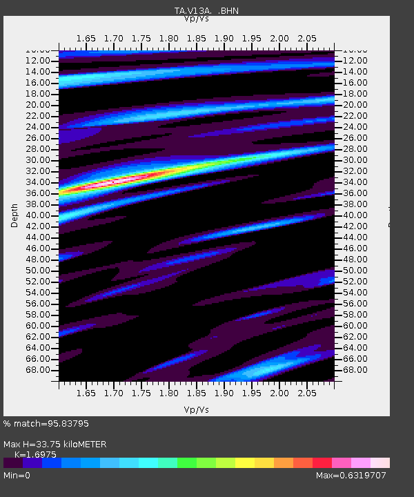
| Estimated Moho Depth: |
33.75 km |
| Estimated Crust Vp/Vs: |
1.70 |
| Assumed Crust Vp: |
6.276 km/s |
| Estimated Crust Vs: |
3.697 km/s |
| Estimated Crust Poisson's Ratio: |
0.23 |
|
| Radial Match: |
95.83795 % |
| Radial Bump: |
400 |
| Transverse Match: |
87.93465 % |
| Transverse Bump: |
400 |
| SOD ConfigId: |
2564 |
| Insert Time: |
2010-03-07 05:25:06.281 +0000 |
| GWidth: |
2.5 |
| Max Bumps: |
400 |
| Tol: |
0.001 |
|
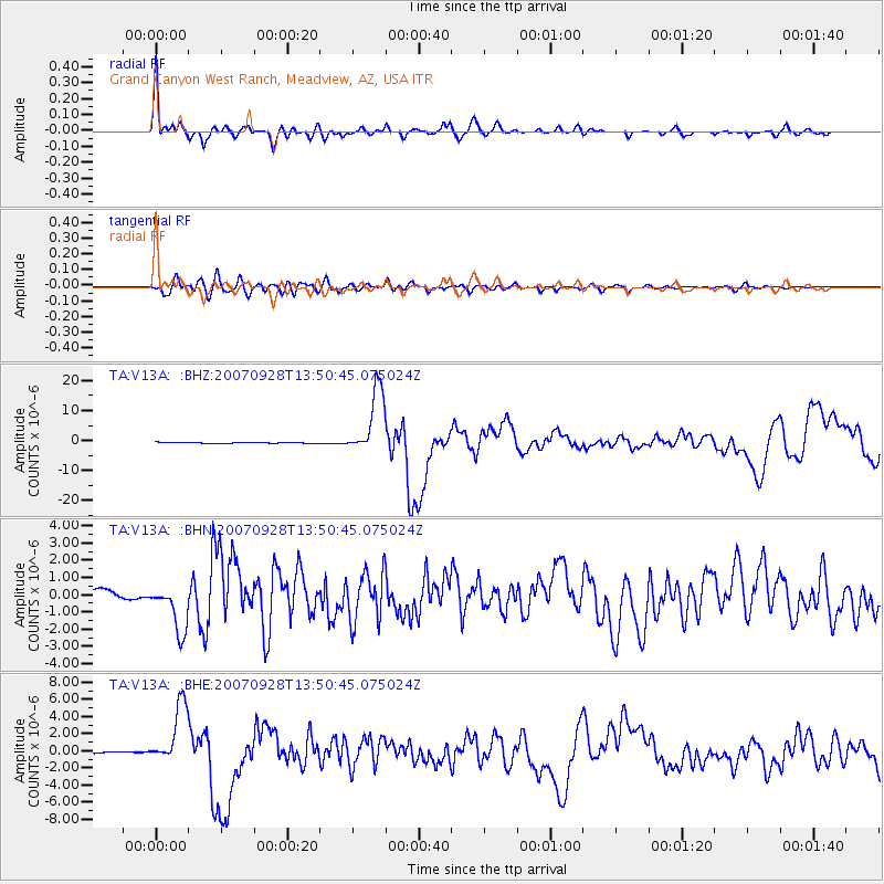
Signal To Noise
| Channel | StoN | STA | LTA |
| TA:V13A: :BHN:20070928T13:50:45.075024Z | 7.034188 | 1.4438767E-6 | 2.052656E-7 |
| TA:V13A: :BHE:20070928T13:50:45.075024Z | 23.754572 | 3.5887015E-6 | 1.5107413E-7 |
| TA:V13A: :BHZ:20070928T13:50:45.075024Z | 80.66801 | 1.1095818E-5 | 1.3754916E-7 |
| Arrivals |
| Ps | 3.8 SECOND |
| PpPs | 14 SECOND |
| PsPs/PpSs | 18 SECOND |


