You are here: Home > Network List > TA - USArray Transportable Network (new EarthScope stations) Stations List
> Station V13A Grand Canyon West Ranch, Meadview, AZ, USA > Earthquake Result Viewer
V13A Grand Canyon West Ranch, Meadview, AZ, USA - Earthquake Result Viewer
| Earthquake location: |
Sea Of Japan |
| Earthquake latitude/longitude: |
36.8/134.9 |
| Earthquake time(UTC): |
2007/07/16 (197) 14:17:37 GMT |
| Earthquake Depth: |
350 km |
| Earthquake Magnitude: |
6.2 MB, 6.8 MW, 6.8 MW |
| Earthquake Catalog/Contributor: |
WHDF/NEIC |
|
| Network: |
TA USArray Transportable Network (new EarthScope stations) |
| Station: |
V13A Grand Canyon West Ranch, Meadview, AZ, USA |
| Lat/Lon: |
35.85 N/113.98 W |
| Elevation: |
1402 m |
|
| Distance: |
83.5 deg |
| Az: |
49.678 deg |
| Baz: |
311.131 deg |
| Ray Param: |
0.04519275 |
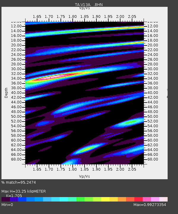
| Estimated Moho Depth: |
33.25 km |
| Estimated Crust Vp/Vs: |
1.71 |
| Assumed Crust Vp: |
6.276 km/s |
| Estimated Crust Vs: |
3.681 km/s |
| Estimated Crust Poisson's Ratio: |
0.24 |
|
| Radial Match: |
95.2474 % |
| Radial Bump: |
400 |
| Transverse Match: |
82.48688 % |
| Transverse Bump: |
400 |
| SOD ConfigId: |
2564 |
| Insert Time: |
2010-03-07 05:25:35.231 +0000 |
| GWidth: |
2.5 |
| Max Bumps: |
400 |
| Tol: |
0.001 |
|

Signal To Noise
| Channel | StoN | STA | LTA |
| TA:V13A: :BHN:20070716T14:28:55.62302Z | 7.302461 | 3.193057E-7 | 4.372577E-8 |
| TA:V13A: :BHE:20070716T14:28:55.62302Z | 12.93553 | 4.1593057E-7 | 3.215412E-8 |
| TA:V13A: :BHZ:20070716T14:28:55.62302Z | 29.955957 | 1.4054183E-6 | 4.6916153E-8 |
| Arrivals |
| Ps | 3.8 SECOND |
| PpPs | 14 SECOND |
| PsPs/PpSs | 18 SECOND |


