You are here: Home > Network List > TA - USArray Transportable Network (new EarthScope stations) Stations List
> Station V13A Grand Canyon West Ranch, Meadview, AZ, USA > Earthquake Result Viewer
V13A Grand Canyon West Ranch, Meadview, AZ, USA - Earthquake Result Viewer
| Earthquake location: |
Loyalty Islands |
| Earthquake latitude/longitude: |
-20.1/168.9 |
| Earthquake time(UTC): |
2008/04/09 (100) 12:46:12 GMT |
| Earthquake Depth: |
33 km |
| Earthquake Magnitude: |
6.3 MB, 7.3 MS, 7.3 MW, 7.3 MW |
| Earthquake Catalog/Contributor: |
WHDF/NEIC |
|
| Network: |
TA USArray Transportable Network (new EarthScope stations) |
| Station: |
V13A Grand Canyon West Ranch, Meadview, AZ, USA |
| Lat/Lon: |
35.85 N/113.98 W |
| Elevation: |
1402 m |
|
| Distance: |
91.6 deg |
| Az: |
52.4 deg |
| Baz: |
246.455 deg |
| Ray Param: |
0.041569512 |
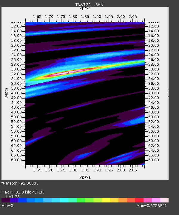
| Estimated Moho Depth: |
31.0 km |
| Estimated Crust Vp/Vs: |
1.78 |
| Assumed Crust Vp: |
6.276 km/s |
| Estimated Crust Vs: |
3.526 km/s |
| Estimated Crust Poisson's Ratio: |
0.27 |
|
| Radial Match: |
92.08003 % |
| Radial Bump: |
304 |
| Transverse Match: |
79.92392 % |
| Transverse Bump: |
400 |
| SOD ConfigId: |
2504 |
| Insert Time: |
2010-03-07 05:25:49.547 +0000 |
| GWidth: |
2.5 |
| Max Bumps: |
400 |
| Tol: |
0.001 |
|
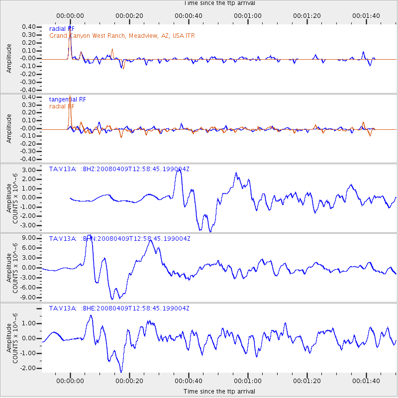
Signal To Noise
| Channel | StoN | STA | LTA |
| TA:V13A: :BHN:20080409T12:58:45.199004Z | 3.325842 | 9.329839E-7 | 2.8052563E-7 |
| TA:V13A: :BHE:20080409T12:58:45.199004Z | 0.2881128 | 5.671449E-8 | 1.9684822E-7 |
| TA:V13A: :BHZ:20080409T12:58:45.199004Z | 1.1446462 | 2.663871E-7 | 2.3272443E-7 |
| Arrivals |
| Ps | 3.9 SECOND |
| PpPs | 13 SECOND |
| PsPs/PpSs | 17 SECOND |


