You are here: Home > Network List > TA - USArray Transportable Network (new EarthScope stations) Stations List
> Station Y15A Casa Rosa Ranch, Morristown, AZ, USA > Earthquake Result Viewer
Y15A Casa Rosa Ranch, Morristown, AZ, USA - Earthquake Result Viewer
| Earthquake location: |
Central Mid-Atlantic Ridge |
| Earthquake latitude/longitude: |
8.1/-38.7 |
| Earthquake time(UTC): |
2008/09/10 (254) 13:08:14 GMT |
| Earthquake Depth: |
10 km |
| Earthquake Magnitude: |
6.3 MB, 6.5 MS, 6.6 MW, 6.6 MW |
| Earthquake Catalog/Contributor: |
WHDF/NEIC |
|
| Network: |
TA USArray Transportable Network (new EarthScope stations) |
| Station: |
Y15A Casa Rosa Ranch, Morristown, AZ, USA |
| Lat/Lon: |
33.95 N/112.33 W |
| Elevation: |
572 m |
|
| Distance: |
71.9 deg |
| Az: |
302.99 deg |
| Baz: |
92.354 deg |
| Ray Param: |
0.053988874 |
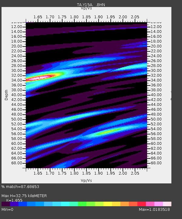
| Estimated Moho Depth: |
32.75 km |
| Estimated Crust Vp/Vs: |
1.65 |
| Assumed Crust Vp: |
6.264 km/s |
| Estimated Crust Vs: |
3.785 km/s |
| Estimated Crust Poisson's Ratio: |
0.21 |
|
| Radial Match: |
87.68653 % |
| Radial Bump: |
281 |
| Transverse Match: |
76.92913 % |
| Transverse Bump: |
378 |
| SOD ConfigId: |
2504 |
| Insert Time: |
2010-03-07 05:27:09.761 +0000 |
| GWidth: |
2.5 |
| Max Bumps: |
400 |
| Tol: |
0.001 |
|

Signal To Noise
| Channel | StoN | STA | LTA |
| TA:Y15A: :BHN:20080910T13:19:07.125027Z | 2.0039978 | 3.3166188E-7 | 1.6550011E-7 |
| TA:Y15A: :BHE:20080910T13:19:07.125027Z | 1.3912462 | 1.9258583E-7 | 1.3842686E-7 |
| TA:Y15A: :BHZ:20080910T13:19:07.125027Z | 1.01928 | 1.5854421E-7 | 1.5554531E-7 |
| Arrivals |
| Ps | 3.6 SECOND |
| PpPs | 13 SECOND |
| PsPs/PpSs | 17 SECOND |


