You are here: Home > Network List > TA - USArray Transportable Network (new EarthScope stations) Stations List
> Station Y15A Casa Rosa Ranch, Morristown, AZ, USA > Earthquake Result Viewer
Y15A Casa Rosa Ranch, Morristown, AZ, USA - Earthquake Result Viewer
| Earthquake location: |
Kuril Islands |
| Earthquake latitude/longitude: |
46.4/153.2 |
| Earthquake time(UTC): |
2008/03/03 (063) 09:31:02 GMT |
| Earthquake Depth: |
10 km |
| Earthquake Magnitude: |
6.2 MB, 6.5 MS, 6.5 MW, 6.5 MW |
| Earthquake Catalog/Contributor: |
WHDF/NEIC |
|
| Network: |
TA USArray Transportable Network (new EarthScope stations) |
| Station: |
Y15A Casa Rosa Ranch, Morristown, AZ, USA |
| Lat/Lon: |
33.95 N/112.33 W |
| Elevation: |
572 m |
|
| Distance: |
69.1 deg |
| Az: |
62.483 deg |
| Baz: |
312.413 deg |
| Ray Param: |
0.05585316 |
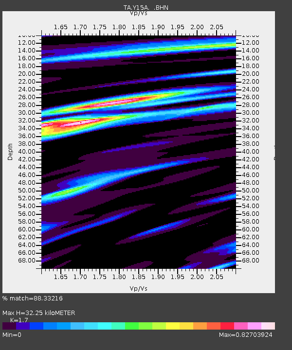
| Estimated Moho Depth: |
32.25 km |
| Estimated Crust Vp/Vs: |
1.70 |
| Assumed Crust Vp: |
6.264 km/s |
| Estimated Crust Vs: |
3.684 km/s |
| Estimated Crust Poisson's Ratio: |
0.24 |
|
| Radial Match: |
88.33216 % |
| Radial Bump: |
345 |
| Transverse Match: |
70.903984 % |
| Transverse Bump: |
400 |
| SOD ConfigId: |
2564 |
| Insert Time: |
2010-03-07 05:27:14.070 +0000 |
| GWidth: |
2.5 |
| Max Bumps: |
400 |
| Tol: |
0.001 |
|
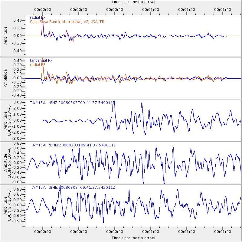
Signal To Noise
| Channel | StoN | STA | LTA |
| TA:Y15A: :BHN:20080303T09:41:37.549011Z | 0.6093292 | 1.1571732E-7 | 1.8990936E-7 |
| TA:Y15A: :BHE:20080303T09:41:37.549011Z | 1.9464275 | 3.1356618E-7 | 1.6109831E-7 |
| TA:Y15A: :BHZ:20080303T09:41:37.549011Z | 4.0078926 | 5.85411E-7 | 1.4606454E-7 |
| Arrivals |
| Ps | 3.7 SECOND |
| PpPs | 13 SECOND |
| PsPs/PpSs | 17 SECOND |


