You are here: Home > Network List > TS - TERRAscope (Southern California Seismic Network) Stations List
> Station PAS Pasadena, California, USA > Earthquake Result Viewer
PAS Pasadena, California, USA - Earthquake Result Viewer
| Earthquake location: |
Santiago Del Estero Prov., Arg. |
| Earthquake latitude/longitude: |
-28.3/-63.0 |
| Earthquake time(UTC): |
2000/04/23 (114) 09:27:23 GMT |
| Earthquake Depth: |
608 km |
| Earthquake Magnitude: |
6.6 MB, 7.0 MW, 7.0 MW |
| Earthquake Catalog/Contributor: |
WHDF/NEIC |
|
| Network: |
TS TERRAscope (Southern California Seismic Network) |
| Station: |
PAS Pasadena, California, USA |
| Lat/Lon: |
34.15 N/118.17 W |
| Elevation: |
295 m |
|
| Distance: |
81.1 deg |
| Az: |
316.444 deg |
| Baz: |
132.894 deg |
| Ray Param: |
0.0459186 |
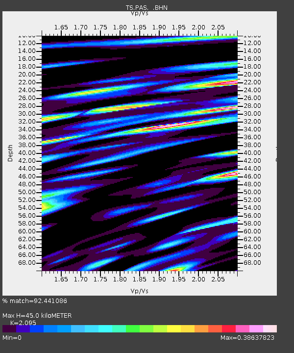
| Estimated Moho Depth: |
45.0 km |
| Estimated Crust Vp/Vs: |
2.10 |
| Assumed Crust Vp: |
6.1 km/s |
| Estimated Crust Vs: |
2.912 km/s |
| Estimated Crust Poisson's Ratio: |
0.35 |
|
| Radial Match: |
92.441086 % |
| Radial Bump: |
400 |
| Transverse Match: |
87.91539 % |
| Transverse Bump: |
400 |
| SOD ConfigId: |
3744 |
| Insert Time: |
2010-02-26 14:32:41.636 +0000 |
| GWidth: |
2.5 |
| Max Bumps: |
400 |
| Tol: |
0.001 |
|
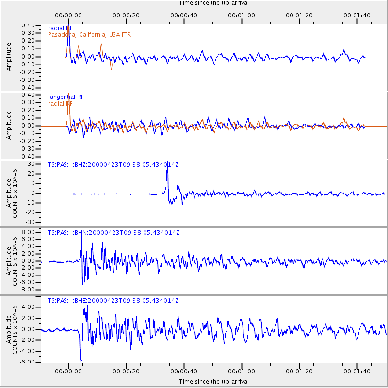
Signal To Noise
| Channel | StoN | STA | LTA |
| TS:PAS: :BHN:20000423T09:38:05.434014Z | 16.83341 | 2.2127247E-6 | 1.3144839E-7 |
| TS:PAS: :BHE:20000423T09:38:05.434014Z | 15.487153 | 2.0241134E-6 | 1.306963E-7 |
| TS:PAS: :BHZ:20000423T09:38:05.434014Z | 42.12319 | 8.703405E-6 | 2.066179E-7 |
| Arrivals |
| Ps | 8.2 SECOND |
| PpPs | 22 SECOND |
| PsPs/PpSs | 31 SECOND |


