You are here: Home > Network List > TA - USArray Transportable Network (new EarthScope stations) Stations List
> Station Y15A Casa Rosa Ranch, Morristown, AZ, USA > Earthquake Result Viewer
Y15A Casa Rosa Ranch, Morristown, AZ, USA - Earthquake Result Viewer
| Earthquake location: |
South Of Fiji Islands |
| Earthquake latitude/longitude: |
-25.8/179.5 |
| Earthquake time(UTC): |
2007/10/16 (289) 21:05:43 GMT |
| Earthquake Depth: |
509 km |
| Earthquake Magnitude: |
6.2 MB, 6.6 MW, 6.5 MW |
| Earthquake Catalog/Contributor: |
WHDF/NEIC |
|
| Network: |
TA USArray Transportable Network (new EarthScope stations) |
| Station: |
Y15A Casa Rosa Ranch, Morristown, AZ, USA |
| Lat/Lon: |
33.95 N/112.33 W |
| Elevation: |
572 m |
|
| Distance: |
87.8 deg |
| Az: |
50.535 deg |
| Baz: |
236.869 deg |
| Ray Param: |
0.04172818 |
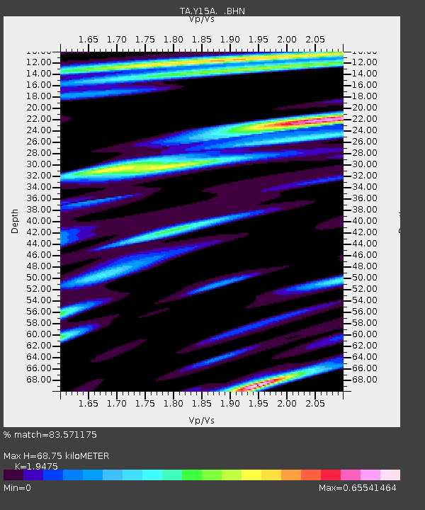
| Estimated Moho Depth: |
68.75 km |
| Estimated Crust Vp/Vs: |
1.95 |
| Assumed Crust Vp: |
6.264 km/s |
| Estimated Crust Vs: |
3.216 km/s |
| Estimated Crust Poisson's Ratio: |
0.32 |
|
| Radial Match: |
83.571175 % |
| Radial Bump: |
400 |
| Transverse Match: |
68.76882 % |
| Transverse Bump: |
400 |
| SOD ConfigId: |
2564 |
| Insert Time: |
2010-03-07 05:27:29.617 +0000 |
| GWidth: |
2.5 |
| Max Bumps: |
400 |
| Tol: |
0.001 |
|

Signal To Noise
| Channel | StoN | STA | LTA |
| TA:Y15A: :BHN:20071016T21:17:06.449016Z | 9.660263 | 7.9106934E-7 | 8.1889006E-8 |
| TA:Y15A: :BHE:20071016T21:17:06.449016Z | 7.4629273 | 1.3759026E-6 | 1.84365E-7 |
| TA:Y15A: :BHZ:20071016T21:17:06.449016Z | 40.763542 | 4.3391024E-6 | 1.0644567E-7 |
| Arrivals |
| Ps | 11 SECOND |
| PpPs | 32 SECOND |
| PsPs/PpSs | 42 SECOND |


