You are here: Home > Network List > TA - USArray Transportable Network (new EarthScope stations) Stations List
> Station Y15A Casa Rosa Ranch, Morristown, AZ, USA > Earthquake Result Viewer
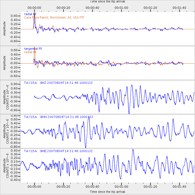
Y15A Casa Rosa Ranch, Morristown, AZ, USA - Earthquake Result Viewer

| Earthquake location: |
Central East Pacific Rise |
| Earthquake latitude/longitude: |
-4.8/-105.4 |
| Earthquake time(UTC): |
2007/08/04 (216) 14:24:51 GMT |
| Earthquake Depth: |
10 km |
| Earthquake Magnitude: |
5.7 MS, 5.4 MB, 6.0 MW, 5.9 MW |
| Earthquake Catalog/Contributor: |
WHDF/NEIC |
|
| Network: |
TA USArray Transportable Network (new EarthScope stations) |
| Station: |
Y15A Casa Rosa Ranch, Morristown, AZ, USA |
| Lat/Lon: |
33.95 N/112.33 W |
| Elevation: |
572 m |
|
| Distance: |
39.1 deg |
| Az: |
350.852 deg |
| Baz: |
169.012 deg |
| Ray Param: |
0.07518344 |
| Estimated Moho Depth: |
43.25 km |
| Estimated Crust Vp/Vs: |
1.71 |
| Assumed Crust Vp: |
6.264 km/s |
| Estimated Crust Vs: |
3.663 km/s |
| Estimated Crust Poisson's Ratio: |
0.24 |
|
| Radial Match: |
89.914566 % |
| Radial Bump: |
400 |
| Transverse Match: |
70.22656 % |
| Transverse Bump: |
400 |
| SOD ConfigId: |
2564 |
| Insert Time: |
2010-03-07 05:27:42.822 +0000 |
| GWidth: |
2.5 |
| Max Bumps: |
400 |
| Tol: |
0.001 |
|
Signal To Noise
| Channel | StoN | STA | LTA |
| TA:Y15A: :BHN:20070804T14:31:48.100013Z | 2.043357 | 9.2587165E-8 | 4.5311303E-8 |
| TA:Y15A: :BHE:20070804T14:31:48.100013Z | 0.7037077 | 3.9286913E-8 | 5.5828455E-8 |
| TA:Y15A: :BHZ:20070804T14:31:48.100013Z | 1.1678365 | 1.09016966E-7 | 9.334951E-8 |
| Arrivals |
| Ps | 5.3 SECOND |
| PpPs | 17 SECOND |
| PsPs/PpSs | 23 SECOND |


