You are here: Home > Network List > TA - USArray Transportable Network (new EarthScope stations) Stations List
> Station Y15A Casa Rosa Ranch, Morristown, AZ, USA > Earthquake Result Viewer
Y15A Casa Rosa Ranch, Morristown, AZ, USA - Earthquake Result Viewer

| Earthquake location: |
Vanuatu Islands |
| Earthquake latitude/longitude: |
-15.6/167.7 |
| Earthquake time(UTC): |
2007/08/01 (213) 17:08:51 GMT |
| Earthquake Depth: |
120 km |
| Earthquake Magnitude: |
6.2 MB, 7.2 MW, 7.2 MW |
| Earthquake Catalog/Contributor: |
WHDF/NEIC |
|
| Network: |
TA USArray Transportable Network (new EarthScope stations) |
| Station: |
Y15A Casa Rosa Ranch, Morristown, AZ, USA |
| Lat/Lon: |
33.95 N/112.33 W |
| Elevation: |
572 m |
|
| Distance: |
90.5 deg |
| Az: |
54.945 deg |
| Baz: |
251.625 deg |
| Ray Param: |
0.041642565 |
| Estimated Moho Depth: |
28.75 km |
| Estimated Crust Vp/Vs: |
1.75 |
| Assumed Crust Vp: |
6.264 km/s |
| Estimated Crust Vs: |
3.569 km/s |
| Estimated Crust Poisson's Ratio: |
0.26 |
|
| Radial Match: |
96.72 % |
| Radial Bump: |
400 |
| Transverse Match: |
91.583725 % |
| Transverse Bump: |
400 |
| SOD ConfigId: |
2564 |
| Insert Time: |
2010-03-07 05:27:47.996 +0000 |
| GWidth: |
2.5 |
| Max Bumps: |
400 |
| Tol: |
0.001 |
|
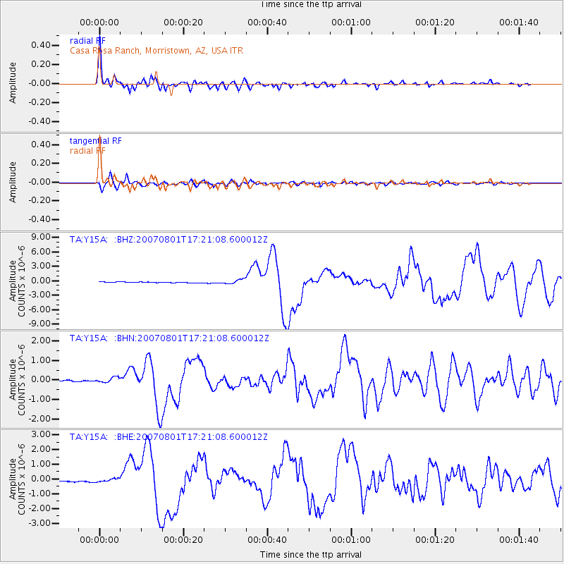
Signal To Noise
| Channel | StoN | STA | LTA |
| TA:Y15A: :BHN:20070801T17:21:08.600012Z | 2.1934993 | 1.3938299E-7 | 6.354366E-8 |
| TA:Y15A: :BHE:20070801T17:21:08.600012Z | 1.825886 | 1.05742345E-7 | 5.7912896E-8 |
| TA:Y15A: :BHZ:20070801T17:21:08.600012Z | 5.1961865 | 4.6597546E-7 | 8.967643E-8 |
| Arrivals |
| Ps | 3.5 SECOND |
| PpPs | 12 SECOND |
| PsPs/PpSs | 16 SECOND |


