You are here: Home > Network List > TS - TERRAscope (Southern California Seismic Network) Stations List
> Station PAS Pasadena, California, USA > Earthquake Result Viewer
PAS Pasadena, California, USA - Earthquake Result Viewer
| Earthquake location: |
Panama |
| Earthquake latitude/longitude: |
9.4/-78.5 |
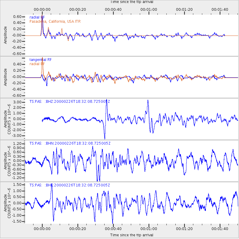
| Earthquake time(UTC): |
2000/02/26 (057) 18:24:39 GMT |
| Earthquake Depth: |
65 km |
| Earthquake Magnitude: |
5.8 MB, 5.4 MS, 6.2 MW, 6.1 MW |
| Earthquake Catalog/Contributor: |
WHDF/NEIC |
|
| Network: |
TS TERRAscope (Southern California Seismic Network) |
| Station: |
PAS Pasadena, California, USA |
| Lat/Lon: |
34.15 N/118.17 W |
| Elevation: |
295 m |
|
| Distance: |
43.9 deg |
| Az: |
310.234 deg |
| Baz: |
114.729 deg |
| Ray Param: |
0.07207453 |
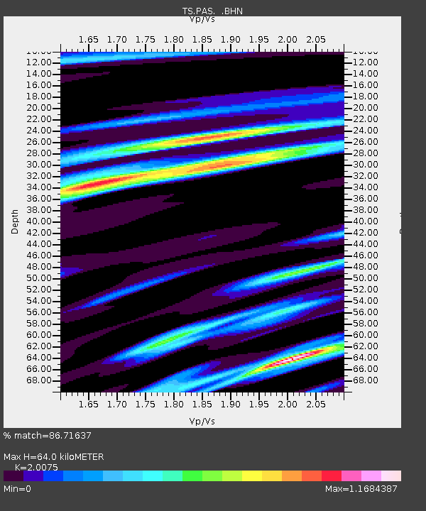
| Estimated Moho Depth: |
64.0 km |
| Estimated Crust Vp/Vs: |
2.01 |
| Assumed Crust Vp: |
6.1 km/s |
| Estimated Crust Vs: |
3.039 km/s |
| Estimated Crust Poisson's Ratio: |
0.33 |
|
| Radial Match: |
86.71637 % |
| Radial Bump: |
387 |
| Transverse Match: |
69.122185 % |
| Transverse Bump: |
400 |
| SOD ConfigId: |
3744 |
| Insert Time: |
2010-02-26 14:32:44.173 +0000 |
| GWidth: |
2.5 |
| Max Bumps: |
400 |
| Tol: |
0.001 |
|
Signal To Noise
| Channel | StoN | STA | LTA |
| TS:PAS: :BHN:20000226T18:32:08.725005Z | 0.9631524 | 2.223695E-7 | 2.3087674E-7 |
| TS:PAS: :BHE:20000226T18:32:08.725005Z | 1.8390732 | 2.2099795E-7 | 1.2016811E-7 |
| TS:PAS: :BHZ:20000226T18:32:08.725005Z | 1.9767954 | 4.743736E-7 | 2.39971E-7 |
| Arrivals |
| Ps | 11 SECOND |
| PpPs | 30 SECOND |
| PsPs/PpSs | 41 SECOND |


