You are here: Home > Network List > GS - US Geological Survey Networks Stations List
> Station KS28 W Mills Ave, Hutchinson KS > Earthquake Result Viewer
KS28 W Mills Ave, Hutchinson KS - Earthquake Result Viewer
| Earthquake location: |
Near Coast Of Central Chile |
| Earthquake latitude/longitude: |
-31.8/-71.4 |
| Earthquake time(UTC): |
2019/11/04 (308) 21:53:24 GMT |
| Earthquake Depth: |
49 km |
| Earthquake Magnitude: |
6.0 Mww |
| Earthquake Catalog/Contributor: |
NEIC PDE/us |
|
| Network: |
GS US Geological Survey Networks |
| Station: |
KS28 W Mills Ave, Hutchinson KS |
| Lat/Lon: |
37.99 N/97.99 W |
| Elevation: |
482 m |
|
| Distance: |
73.8 deg |
| Az: |
338.359 deg |
| Baz: |
156.587 deg |
| Ray Param: |
0.052692883 |
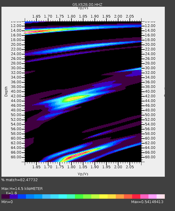
| Estimated Moho Depth: |
14.5 km |
| Estimated Crust Vp/Vs: |
1.60 |
| Assumed Crust Vp: |
6.483 km/s |
| Estimated Crust Vs: |
4.052 km/s |
| Estimated Crust Poisson's Ratio: |
0.18 |
|
| Radial Match: |
82.47732 % |
| Radial Bump: |
400 |
| Transverse Match: |
69.00113 % |
| Transverse Bump: |
400 |
| SOD ConfigId: |
19951751 |
| Insert Time: |
2019-11-18 22:01:29.157 +0000 |
| GWidth: |
2.5 |
| Max Bumps: |
400 |
| Tol: |
0.001 |
|

Signal To Noise
| Channel | StoN | STA | LTA |
| GS:KS28:00:HHZ:20191104T22:04:22.924002Z | 10.426997 | 1.8986043E-6 | 1.8208543E-7 |
| GS:KS28:00:HH1:20191104T22:04:22.924002Z | 2.038561 | 6.6408467E-7 | 3.257615E-7 |
| GS:KS28:00:HH2:20191104T22:04:22.924002Z | 2.0000422 | 6.587267E-7 | 3.2935642E-7 |
| Arrivals |
| Ps | 1.4 SECOND |
| PpPs | 5.6 SECOND |
| PsPs/PpSs | 7.0 SECOND |


