You are here: Home > Network List > IW - Intermountain West Stations List
> Station PLID Pearl Lake, Idaho, USA > Earthquake Result Viewer
PLID Pearl Lake, Idaho, USA - Earthquake Result Viewer
| Earthquake location: |
Near Coast Of Central Chile |
| Earthquake latitude/longitude: |
-31.8/-71.4 |
| Earthquake time(UTC): |
2019/11/04 (308) 21:53:24 GMT |
| Earthquake Depth: |
49 km |
| Earthquake Magnitude: |
6.0 Mww |
| Earthquake Catalog/Contributor: |
NEIC PDE/us |
|
| Network: |
IW Intermountain West |
| Station: |
PLID Pearl Lake, Idaho, USA |
| Lat/Lon: |
45.09 N/116.00 W |
| Elevation: |
2164 m |
|
| Distance: |
86.6 deg |
| Az: |
330.095 deg |
| Baz: |
143.193 deg |
| Ray Param: |
0.04382939 |
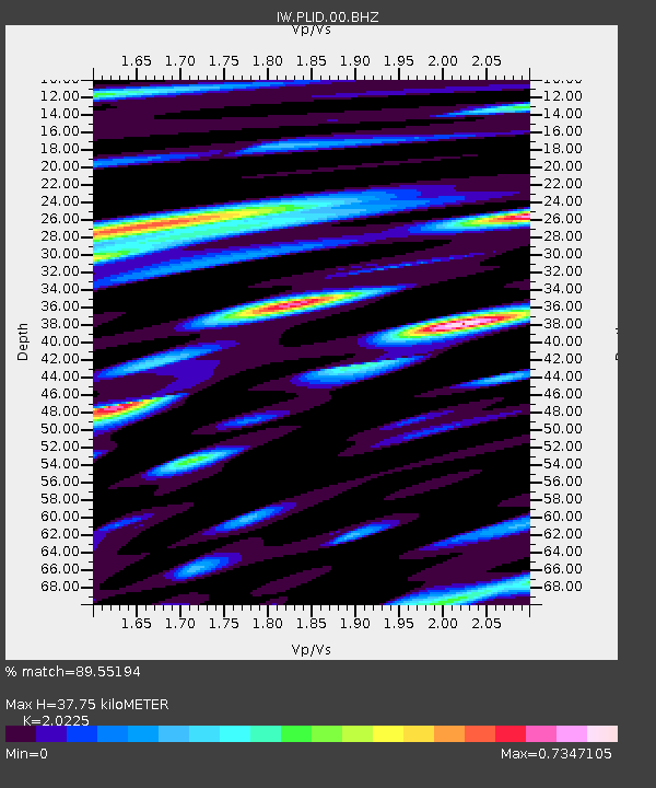
| Estimated Moho Depth: |
37.75 km |
| Estimated Crust Vp/Vs: |
2.02 |
| Assumed Crust Vp: |
6.571 km/s |
| Estimated Crust Vs: |
3.249 km/s |
| Estimated Crust Poisson's Ratio: |
0.34 |
|
| Radial Match: |
89.55194 % |
| Radial Bump: |
400 |
| Transverse Match: |
86.894035 % |
| Transverse Bump: |
400 |
| SOD ConfigId: |
19951751 |
| Insert Time: |
2019-11-18 22:01:52.850 +0000 |
| GWidth: |
2.5 |
| Max Bumps: |
400 |
| Tol: |
0.001 |
|

Signal To Noise
| Channel | StoN | STA | LTA |
| IW:PLID:00:BHZ:20191104T22:05:31.929984Z | 45.397247 | 2.011295E-6 | 4.430434E-8 |
| IW:PLID:00:BH1:20191104T22:05:31.929984Z | 6.583178 | 4.936122E-7 | 7.4980846E-8 |
| IW:PLID:00:BH2:20191104T22:05:31.929984Z | 4.0447702 | 2.892611E-7 | 7.151484E-8 |
| Arrivals |
| Ps | 6.0 SECOND |
| PpPs | 17 SECOND |
| PsPs/PpSs | 23 SECOND |


