You are here: Home > Network List > N4 - Central and EAstern US Network Stations List
> Station S44A Carbondale, IL, USA > Earthquake Result Viewer
S44A Carbondale, IL, USA - Earthquake Result Viewer
| Earthquake location: |
Near Coast Of Central Chile |
| Earthquake latitude/longitude: |
-31.8/-71.4 |
| Earthquake time(UTC): |
2019/11/04 (308) 21:53:24 GMT |
| Earthquake Depth: |
49 km |
| Earthquake Magnitude: |
6.0 Mww |
| Earthquake Catalog/Contributor: |
NEIC PDE/us |
|
| Network: |
N4 Central and EAstern US Network |
| Station: |
S44A Carbondale, IL, USA |
| Lat/Lon: |
37.69 N/89.26 W |
| Elevation: |
155 m |
|
| Distance: |
71.1 deg |
| Az: |
345.079 deg |
| Baz: |
163.96 deg |
| Ray Param: |
0.054426983 |
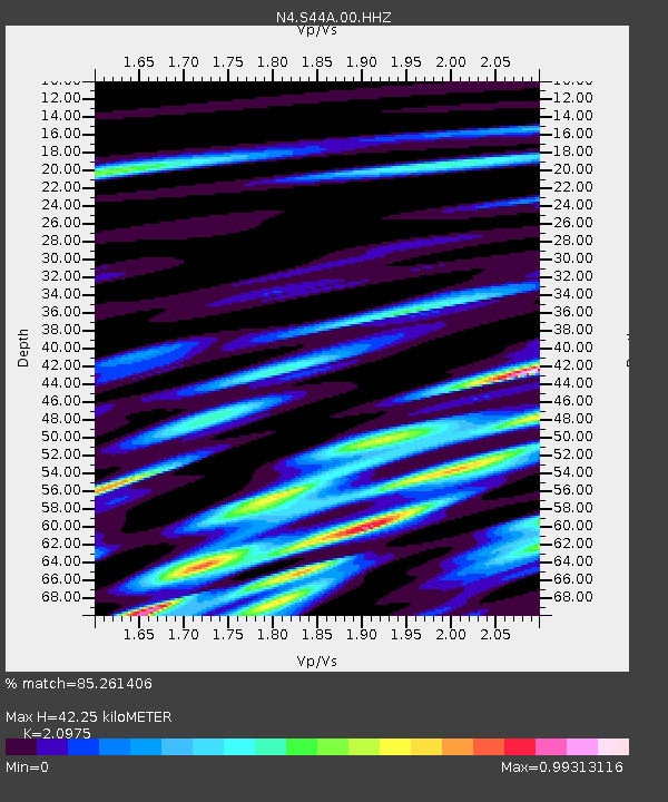
| Estimated Moho Depth: |
42.25 km |
| Estimated Crust Vp/Vs: |
2.10 |
| Assumed Crust Vp: |
6.444 km/s |
| Estimated Crust Vs: |
3.072 km/s |
| Estimated Crust Poisson's Ratio: |
0.35 |
|
| Radial Match: |
85.261406 % |
| Radial Bump: |
400 |
| Transverse Match: |
61.46711 % |
| Transverse Bump: |
400 |
| SOD ConfigId: |
19951751 |
| Insert Time: |
2019-11-18 22:03:08.953 +0000 |
| GWidth: |
2.5 |
| Max Bumps: |
400 |
| Tol: |
0.001 |
|

Signal To Noise
| Channel | StoN | STA | LTA |
| N4:S44A:00:HHZ:20191104T22:04:07.439994Z | 16.794699 | 2.2870981E-6 | 1.3617975E-7 |
| N4:S44A:00:HH1:20191104T22:04:07.439994Z | 7.5037484 | 1.0166099E-6 | 1.3548026E-7 |
| N4:S44A:00:HH2:20191104T22:04:07.439994Z | 2.395175 | 4.3892769E-7 | 1.8325495E-7 |
| Arrivals |
| Ps | 7.4 SECOND |
| PpPs | 20 SECOND |
| PsPs/PpSs | 27 SECOND |


