You are here: Home > Network List > TA - USArray Transportable Network (new EarthScope stations) Stations List
> Station Y15A Casa Rosa Ranch, Morristown, AZ, USA > Earthquake Result Viewer
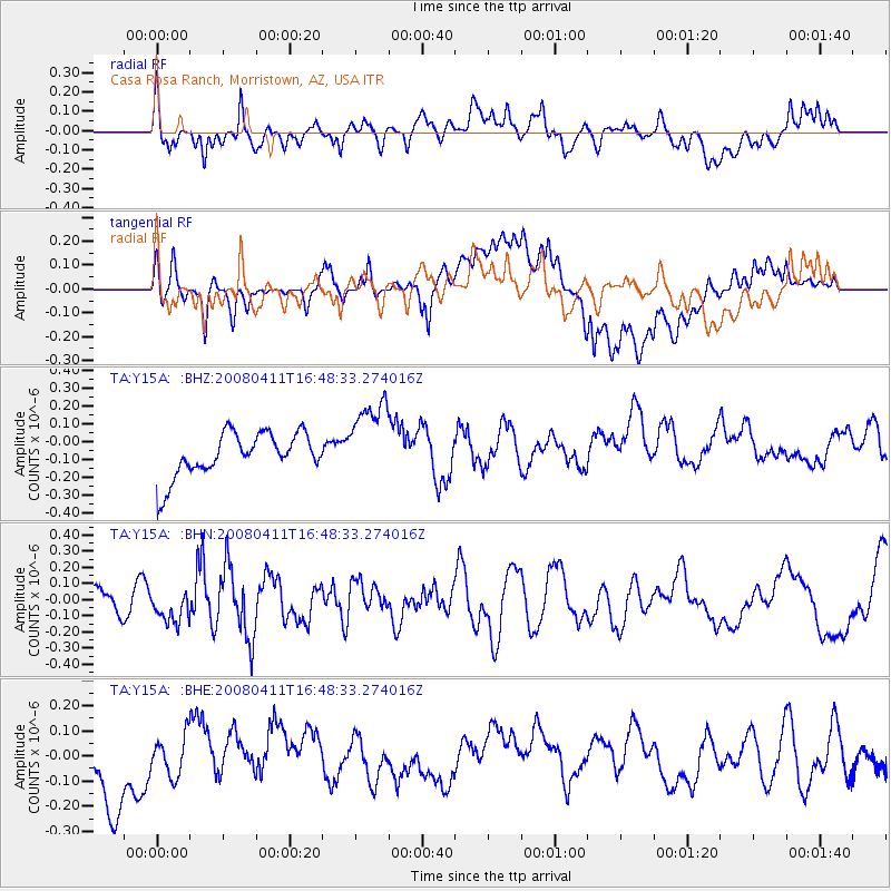
Y15A Casa Rosa Ranch, Morristown, AZ, USA - Earthquake Result Viewer
*The percent match for this event was below the threshold and hence no stack was calculated.
| Earthquake location: |
Loyalty Islands |
| Earthquake latitude/longitude: |
-20.4/168.8 |
| Earthquake time(UTC): |
2008/04/11 (102) 16:35:57 GMT |
| Earthquake Depth: |
35 km |
| Earthquake Magnitude: |
5.6 MS, 5.4 MB, 5.9 MW, 5.9 MW |
| Earthquake Catalog/Contributor: |
WHDF/NEIC |
|
| Network: |
TA USArray Transportable Network (new EarthScope stations) |
| Station: |
Y15A Casa Rosa Ranch, Morristown, AZ, USA |
| Lat/Lon: |
33.95 N/112.33 W |
| Elevation: |
572 m |
|
| Distance: |
92.4 deg |
| Az: |
54.716 deg |
| Baz: |
247.088 deg |
| Ray Param: |
$rayparam |
*The percent match for this event was below the threshold and hence was not used in the summary stack. |
|
| Radial Match: |
59.00067 % |
| Radial Bump: |
400 |
| Transverse Match: |
55.490494 % |
| Transverse Bump: |
400 |
| SOD ConfigId: |
2504 |
| Insert Time: |
2010-03-07 05:28:53.114 +0000 |
| GWidth: |
2.5 |
| Max Bumps: |
400 |
| Tol: |
0.001 |
|
Signal To Noise
| Channel | StoN | STA | LTA |
| TA:Y15A: :BHN:20080411T16:48:33.274016Z | 1.3115895 | 9.7440235E-8 | 7.429172E-8 |
| TA:Y15A: :BHE:20080411T16:48:33.274016Z | 0.49975583 | 8.330185E-8 | 1.6668511E-7 |
| TA:Y15A: :BHZ:20080411T16:48:33.274016Z | 1.8956206 | 2.2943267E-7 | 1.2103301E-7 |
| Arrivals |
| Ps | |
| PpPs | |
| PsPs/PpSs | |


