You are here: Home > Network List > TA - USArray Transportable Network (new EarthScope stations) Stations List
> Station Y15A Casa Rosa Ranch, Morristown, AZ, USA > Earthquake Result Viewer
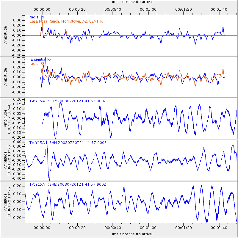
Y15A Casa Rosa Ranch, Morristown, AZ, USA - Earthquake Result Viewer
*The percent match for this event was below the threshold and hence no stack was calculated.
| Earthquake location: |
Bonin Islands, Japan Region |
| Earthquake latitude/longitude: |
27.8/139.6 |
| Earthquake time(UTC): |
2008/07/20 (202) 21:30:29 GMT |
| Earthquake Depth: |
481 km |
| Earthquake Magnitude: |
5.8 MW, 5.1 MB, 5.8 MW |
| Earthquake Catalog/Contributor: |
WHDF/NEIC |
|
| Network: |
TA USArray Transportable Network (new EarthScope stations) |
| Station: |
Y15A Casa Rosa Ranch, Morristown, AZ, USA |
| Lat/Lon: |
33.95 N/112.33 W |
| Elevation: |
572 m |
|
| Distance: |
88.3 deg |
| Az: |
52.246 deg |
| Baz: |
302.559 deg |
| Ray Param: |
$rayparam |
*The percent match for this event was below the threshold and hence was not used in the summary stack. |
|
| Radial Match: |
38.494186 % |
| Radial Bump: |
400 |
| Transverse Match: |
62.69901 % |
| Transverse Bump: |
367 |
| SOD ConfigId: |
2504 |
| Insert Time: |
2010-03-07 05:29:01.599 +0000 |
| GWidth: |
2.5 |
| Max Bumps: |
400 |
| Tol: |
0.001 |
|
Signal To Noise
| Channel | StoN | STA | LTA |
| TA:Y15A: :BHN:20080720T21:41:57.900Z | 2.022745 | 2.265104E-7 | 1.1198169E-7 |
| TA:Y15A: :BHE:20080720T21:41:57.900Z | 1.5325317 | 1.1557871E-7 | 7.541684E-8 |
| TA:Y15A: :BHZ:20080720T21:41:57.900Z | 0.5983323 | 5.2679276E-8 | 8.8043514E-8 |
| Arrivals |
| Ps | |
| PpPs | |
| PsPs/PpSs | |


