You are here: Home > Network List > O2 - Oklahoma Consolidated Temporary Seismic Networks Stations List
> Station SMNL Seminole, Oklahoma, USA > Earthquake Result Viewer
SMNL Seminole, Oklahoma, USA - Earthquake Result Viewer
| Earthquake location: |
Near Coast Of Central Chile |
| Earthquake latitude/longitude: |
-31.8/-71.4 |
| Earthquake time(UTC): |
2019/11/04 (308) 21:53:24 GMT |
| Earthquake Depth: |
49 km |
| Earthquake Magnitude: |
6.0 Mww |
| Earthquake Catalog/Contributor: |
NEIC PDE/us |
|
| Network: |
O2 Oklahoma Consolidated Temporary Seismic Networks |
| Station: |
SMNL Seminole, Oklahoma, USA |
| Lat/Lon: |
35.29 N/96.56 W |
| Elevation: |
317 m |
|
| Distance: |
70.8 deg |
| Az: |
338.364 deg |
| Baz: |
157.437 deg |
| Ray Param: |
0.05462306 |
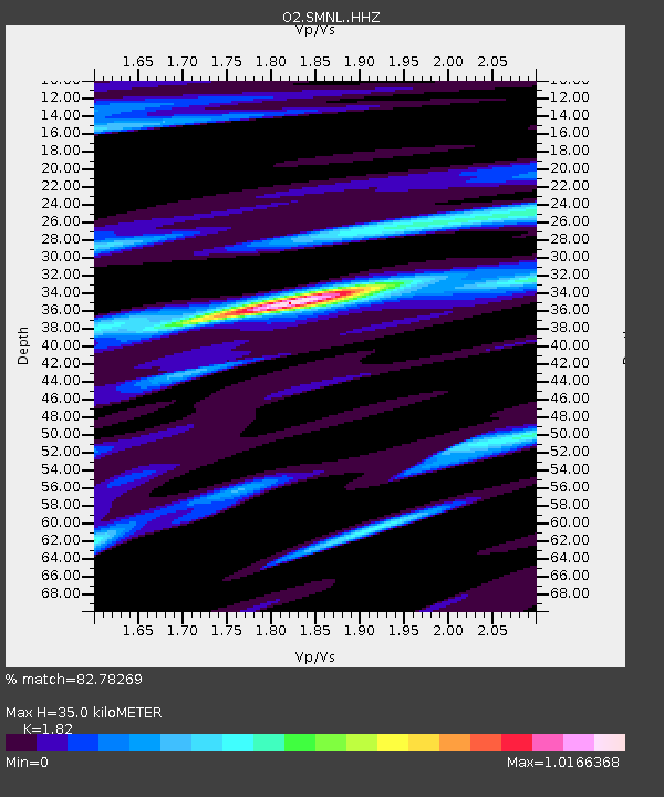
| Estimated Moho Depth: |
35.0 km |
| Estimated Crust Vp/Vs: |
1.82 |
| Assumed Crust Vp: |
6.426 km/s |
| Estimated Crust Vs: |
3.531 km/s |
| Estimated Crust Poisson's Ratio: |
0.28 |
|
| Radial Match: |
82.78269 % |
| Radial Bump: |
400 |
| Transverse Match: |
63.119812 % |
| Transverse Bump: |
400 |
| SOD ConfigId: |
19951751 |
| Insert Time: |
2019-11-18 22:04:36.638 +0000 |
| GWidth: |
2.5 |
| Max Bumps: |
400 |
| Tol: |
0.001 |
|

Signal To Noise
| Channel | StoN | STA | LTA |
| O2:SMNL: :HHZ:20191104T22:04:05.564994Z | 13.175609 | 1.6560739E-6 | 1.2569241E-7 |
| O2:SMNL: :HHN:20191104T22:04:05.564994Z | 3.2330594 | 6.902962E-7 | 2.1351175E-7 |
| O2:SMNL: :HHE:20191104T22:04:05.564994Z | 3.4081972 | 6.795066E-7 | 1.9937421E-7 |
| Arrivals |
| Ps | 4.6 SECOND |
| PpPs | 15 SECOND |
| PsPs/PpSs | 19 SECOND |


