You are here: Home > Network List > TS - TERRAscope (Southern California Seismic Network) Stations List
> Station PAS Pasadena, California, USA > Earthquake Result Viewer
PAS Pasadena, California, USA - Earthquake Result Viewer
| Earthquake location: |
E. Russia-N.E. China Border Reg. |
| Earthquake latitude/longitude: |
43.6/130.4 |
| Earthquake time(UTC): |
1999/04/08 (098) 13:10:34 GMT |
| Earthquake Depth: |
566 km |
| Earthquake Magnitude: |
6.4 MB, 7.1 MW, 7.1 MW |
| Earthquake Catalog/Contributor: |
WHDF/NEIC |
|
| Network: |
TS TERRAscope (Southern California Seismic Network) |
| Station: |
PAS Pasadena, California, USA |
| Lat/Lon: |
34.15 N/118.17 W |
| Elevation: |
295 m |
|
| Distance: |
80.6 deg |
| Az: |
51.468 deg |
| Baz: |
316.751 deg |
| Ray Param: |
0.046459448 |
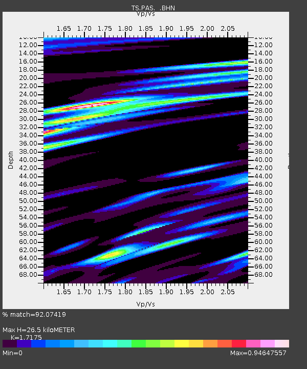
| Estimated Moho Depth: |
26.5 km |
| Estimated Crust Vp/Vs: |
1.72 |
| Assumed Crust Vp: |
6.1 km/s |
| Estimated Crust Vs: |
3.552 km/s |
| Estimated Crust Poisson's Ratio: |
0.24 |
|
| Radial Match: |
92.07419 % |
| Radial Bump: |
400 |
| Transverse Match: |
82.5812 % |
| Transverse Bump: |
400 |
| SOD ConfigId: |
4480 |
| Insert Time: |
2010-02-26 14:32:51.794 +0000 |
| GWidth: |
2.5 |
| Max Bumps: |
400 |
| Tol: |
0.001 |
|

Signal To Noise
| Channel | StoN | STA | LTA |
| TS:PAS: :BHN:19990408T13:21:17.035994Z | 38.587444 | 1.6367005E-5 | 4.2415363E-7 |
| TS:PAS: :BHE:19990408T13:21:17.035994Z | 4.812229 | 2.6526125E-6 | 5.512232E-7 |
| TS:PAS: :BHZ:19990408T13:21:17.035994Z | 7.182359 | 3.0882518E-6 | 4.2997735E-7 |
| Arrivals |
| Ps | 3.2 SECOND |
| PpPs | 12 SECOND |
| PsPs/PpSs | 15 SECOND |


