You are here: Home > Network List > US - United States National Seismic Network Stations List
> Station BOZ Bozeman, Montana, USA > Earthquake Result Viewer
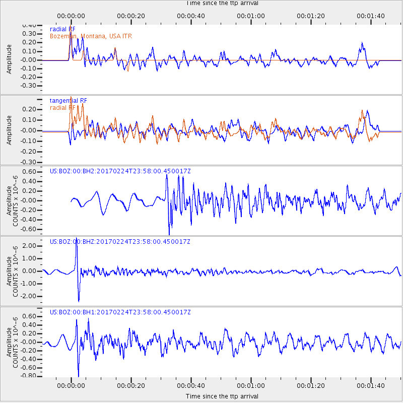
BOZ Bozeman, Montana, USA - Earthquake Result Viewer
*The percent match for this event was below the threshold and hence no stack was calculated.
| Earthquake location: |
Fiji Islands Region |
| Earthquake latitude/longitude: |
-18.0/-178.5 |
| Earthquake time(UTC): |
2017/02/24 (055) 23:46:45 GMT |
| Earthquake Depth: |
581 km |
| Earthquake Magnitude: |
5.9 Mww |
| Earthquake Catalog/Contributor: |
NEIC PDE/us |
|
| Network: |
US United States National Seismic Network |
| Station: |
BOZ Bozeman, Montana, USA |
| Lat/Lon: |
45.65 N/111.63 W |
| Elevation: |
1589 m |
|
| Distance: |
87.5 deg |
| Az: |
40.203 deg |
| Baz: |
241.149 deg |
| Ray Param: |
$rayparam |
*The percent match for this event was below the threshold and hence was not used in the summary stack. |
|
| Radial Match: |
58.03933 % |
| Radial Bump: |
400 |
| Transverse Match: |
51.198433 % |
| Transverse Bump: |
400 |
| SOD ConfigId: |
1992691 |
| Insert Time: |
2017-03-10 23:49:59.311 +0000 |
| GWidth: |
2.5 |
| Max Bumps: |
400 |
| Tol: |
0.001 |
|
Signal To Noise
| Channel | StoN | STA | LTA |
| US:BOZ:00:BHZ:20170224T23:58:00.450017Z | 12.676608 | 9.864802E-7 | 7.7818946E-8 |
| US:BOZ:00:BH1:20170224T23:58:00.450017Z | 3.876658 | 2.5916353E-7 | 6.68523E-8 |
| US:BOZ:00:BH2:20170224T23:58:00.450017Z | 2.5774584 | 2.811401E-7 | 1.0907649E-7 |
| Arrivals |
| Ps | |
| PpPs | |
| PsPs/PpSs | |


