You are here: Home > Network List > US - United States National Seismic Network Stations List
> Station DGMT Dagmar, Montana, USA > Earthquake Result Viewer
DGMT Dagmar, Montana, USA - Earthquake Result Viewer
*The percent match for this event was below the threshold and hence no stack was calculated.
| Earthquake location: |
Fiji Islands Region |
| Earthquake latitude/longitude: |
-18.0/-178.5 |
| Earthquake time(UTC): |
2017/02/24 (055) 23:46:45 GMT |
| Earthquake Depth: |
581 km |
| Earthquake Magnitude: |
5.9 Mww |
| Earthquake Catalog/Contributor: |
NEIC PDE/us |
|
| Network: |
US United States National Seismic Network |
| Station: |
DGMT Dagmar, Montana, USA |
| Lat/Lon: |
48.47 N/104.20 W |
| Elevation: |
0.0 m |
|
| Distance: |
93.3 deg |
| Az: |
39.91 deg |
| Baz: |
246.581 deg |
| Ray Param: |
$rayparam |
*The percent match for this event was below the threshold and hence was not used in the summary stack. |
|
| Radial Match: |
66.552216 % |
| Radial Bump: |
400 |
| Transverse Match: |
66.22304 % |
| Transverse Bump: |
400 |
| SOD ConfigId: |
1992691 |
| Insert Time: |
2017-03-10 23:50:04.207 +0000 |
| GWidth: |
2.5 |
| Max Bumps: |
400 |
| Tol: |
0.001 |
|
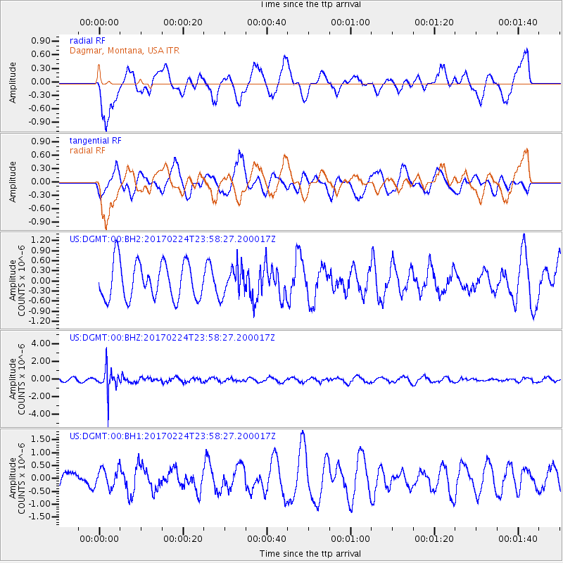
Signal To Noise
| Channel | StoN | STA | LTA |
| US:DGMT:00:BHZ:20170224T23:58:27.200017Z | 7.9635415 | 1.3282448E-6 | 1.6679071E-7 |
| US:DGMT:00:BH1:20170224T23:58:27.200017Z | 0.98981285 | 3.7076464E-7 | 3.7458054E-7 |
| US:DGMT:00:BH2:20170224T23:58:27.200017Z | 0.7515788 | 4.0722935E-7 | 5.4183187E-7 |
| Arrivals |
| Ps | |
| PpPs | |
| PsPs/PpSs | |


