You are here: Home > Network List > US - United States National Seismic Network Stations List
> Station EGMT Eagleton, Montana, USA > Earthquake Result Viewer
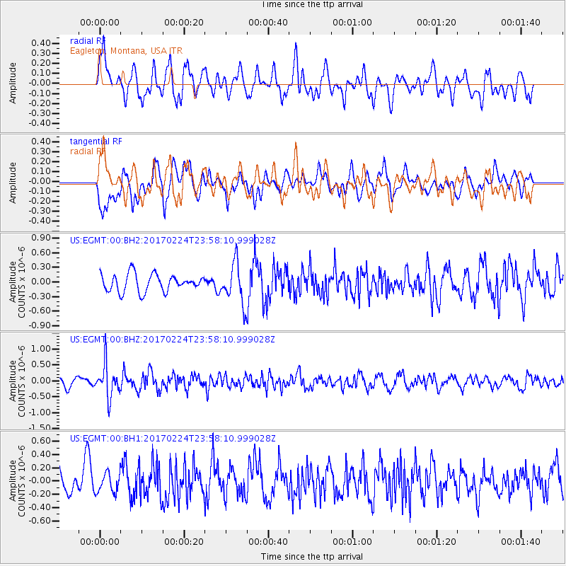
EGMT Eagleton, Montana, USA - Earthquake Result Viewer
*The percent match for this event was below the threshold and hence no stack was calculated.
| Earthquake location: |
Fiji Islands Region |
| Earthquake latitude/longitude: |
-18.0/-178.5 |
| Earthquake time(UTC): |
2017/02/24 (055) 23:46:45 GMT |
| Earthquake Depth: |
581 km |
| Earthquake Magnitude: |
5.9 Mww |
| Earthquake Catalog/Contributor: |
NEIC PDE/us |
|
| Network: |
US United States National Seismic Network |
| Station: |
EGMT Eagleton, Montana, USA |
| Lat/Lon: |
48.02 N/109.75 W |
| Elevation: |
1055 m |
|
| Distance: |
89.7 deg |
| Az: |
38.715 deg |
| Baz: |
242.476 deg |
| Ray Param: |
$rayparam |
*The percent match for this event was below the threshold and hence was not used in the summary stack. |
|
| Radial Match: |
53.035686 % |
| Radial Bump: |
400 |
| Transverse Match: |
49.00603 % |
| Transverse Bump: |
400 |
| SOD ConfigId: |
1992691 |
| Insert Time: |
2017-03-10 23:50:08.227 +0000 |
| GWidth: |
2.5 |
| Max Bumps: |
400 |
| Tol: |
0.001 |
|
Signal To Noise
| Channel | StoN | STA | LTA |
| US:EGMT:00:BHZ:20170224T23:58:10.999028Z | 3.9330924 | 5.2890533E-7 | 1.344757E-7 |
| US:EGMT:00:BH1:20170224T23:58:10.999028Z | 0.6633112 | 1.4329005E-7 | 2.1602236E-7 |
| US:EGMT:00:BH2:20170224T23:58:10.999028Z | 2.4051409 | 4.288199E-7 | 1.7829305E-7 |
| Arrivals |
| Ps | |
| PpPs | |
| PsPs/PpSs | |


