You are here: Home > Network List > WY - Yellowstone Wyoming Seismic Network Stations List
> Station YHH Holmes Hill, YNP, WY, USA > Earthquake Result Viewer
YHH Holmes Hill, YNP, WY, USA - Earthquake Result Viewer
| Earthquake location: |
Near Coast Of Central Chile |
| Earthquake latitude/longitude: |
-31.8/-71.4 |
| Earthquake time(UTC): |
2019/11/04 (308) 21:53:24 GMT |
| Earthquake Depth: |
49 km |
| Earthquake Magnitude: |
6.0 Mww |
| Earthquake Catalog/Contributor: |
NEIC PDE/us |
|
| Network: |
WY Yellowstone Wyoming Seismic Network |
| Station: |
YHH Holmes Hill, YNP, WY, USA |
| Lat/Lon: |
44.79 N/110.85 W |
| Elevation: |
2717 m |
|
| Distance: |
84.3 deg |
| Az: |
332.933 deg |
| Baz: |
147.045 deg |
| Ray Param: |
0.045502525 |
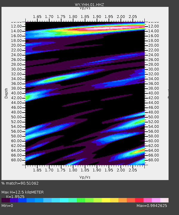
| Estimated Moho Depth: |
12.5 km |
| Estimated Crust Vp/Vs: |
1.95 |
| Assumed Crust Vp: |
6.35 km/s |
| Estimated Crust Vs: |
3.252 km/s |
| Estimated Crust Poisson's Ratio: |
0.32 |
|
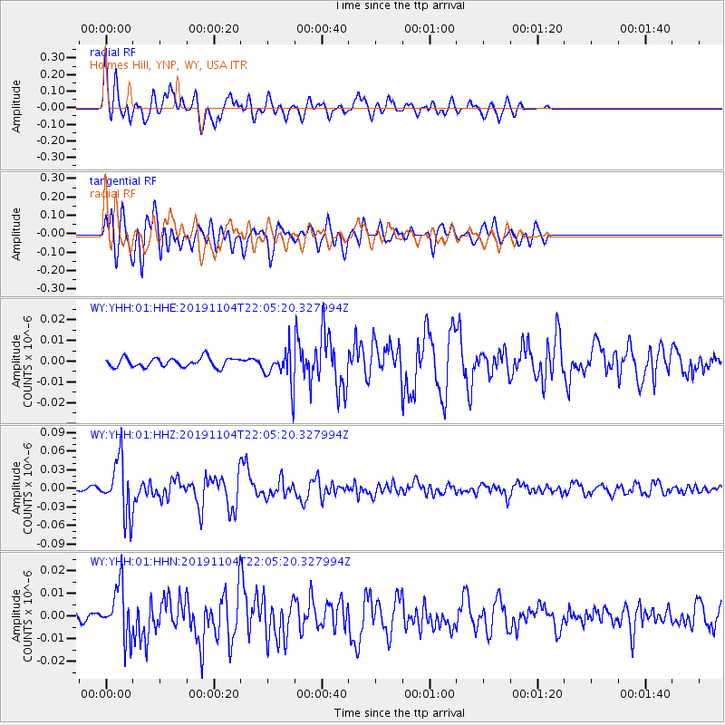
| Radial Match: |
90.51062 % |
| Radial Bump: |
400 |
| Transverse Match: |
88.49424 % |
| Transverse Bump: |
400 |
| SOD ConfigId: |
19951751 |
| Insert Time: |
2019-11-18 22:09:05.545 +0000 |
| GWidth: |
2.5 |
| Max Bumps: |
400 |
| Tol: |
0.001 |
|
Signal To Noise
| Channel | StoN | STA | LTA |
| WY:YHH:01:HHZ:20191104T22:05:20.327994Z | 23.059202 | 4.4925564E-8 | 1.9482704E-9 |
| WY:YHH:01:HHN:20191104T22:05:20.327994Z | 4.608467 | 1.1475949E-8 | 2.4901878E-9 |
| WY:YHH:01:HHE:20191104T22:05:20.327994Z | 3.8137345 | 8.433683E-9 | 2.2113975E-9 |
| Arrivals |
| Ps | 1.9 SECOND |
| PpPs | 5.7 SECOND |
| PsPs/PpSs | 7.6 SECOND |


