You are here: Home > Network List > AE - Arizona Broadband Seismic Network Stations List
> Station TONTO Roosevelt/Tonto Basin > Earthquake Result Viewer
TONTO Roosevelt/Tonto Basin - Earthquake Result Viewer
| Earthquake location: |
Tonga Islands |
| Earthquake latitude/longitude: |
-18.4/-175.2 |
| Earthquake time(UTC): |
2019/11/04 (308) 22:43:37 GMT |
| Earthquake Depth: |
10 km |
| Earthquake Magnitude: |
6.9 Mi |
| Earthquake Catalog/Contributor: |
NEIC PDE/at |
|
| Network: |
AE Arizona Broadband Seismic Network |
| Station: |
TONTO Roosevelt/Tonto Basin |
| Lat/Lon: |
33.65 N/111.01 W |
| Elevation: |
661 m |
|
| Distance: |
80.1 deg |
| Az: |
49.666 deg |
| Baz: |
240.193 deg |
| Ray Param: |
0.048501458 |
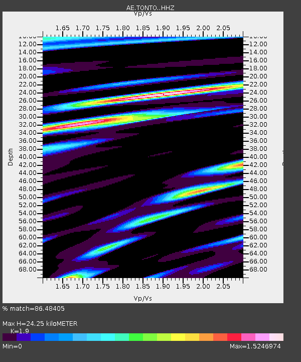
| Estimated Moho Depth: |
24.25 km |
| Estimated Crust Vp/Vs: |
1.90 |
| Assumed Crust Vp: |
6.276 km/s |
| Estimated Crust Vs: |
3.303 km/s |
| Estimated Crust Poisson's Ratio: |
0.31 |
|
| Radial Match: |
86.48405 % |
| Radial Bump: |
389 |
| Transverse Match: |
75.9817 % |
| Transverse Bump: |
400 |
| SOD ConfigId: |
19951751 |
| Insert Time: |
2019-11-18 22:50:27.851 +0000 |
| GWidth: |
2.5 |
| Max Bumps: |
400 |
| Tol: |
0.001 |
|

Signal To Noise
| Channel | StoN | STA | LTA |
| AE:TONTO: :HHZ:20191104T22:55:15.599976Z | 10.799716 | 1.5650851E-6 | 1.449191E-7 |
| AE:TONTO: :HHN:20191104T22:55:15.599976Z | 3.634819 | 4.4569012E-7 | 1.2261687E-7 |
| AE:TONTO: :HHE:20191104T22:55:15.599976Z | 3.3627698 | 5.328042E-7 | 1.5844206E-7 |
| Arrivals |
| Ps | 3.6 SECOND |
| PpPs | 11 SECOND |
| PsPs/PpSs | 14 SECOND |


