You are here: Home > Network List > AK - Alaska Regional Network Stations List
> Station O18K Koktuh Hills, AK, USA > Earthquake Result Viewer
O18K Koktuh Hills, AK, USA - Earthquake Result Viewer
| Earthquake location: |
Tonga Islands |
| Earthquake latitude/longitude: |
-18.4/-175.2 |
| Earthquake time(UTC): |
2019/11/04 (308) 22:43:37 GMT |
| Earthquake Depth: |
10 km |
| Earthquake Magnitude: |
6.9 Mi |
| Earthquake Catalog/Contributor: |
NEIC PDE/at |
|
| Network: |
AK Alaska Regional Network |
| Station: |
O18K Koktuh Hills, AK, USA |
| Lat/Lon: |
59.85 N/155.21 W |
| Elevation: |
544 m |
|
| Distance: |
79.7 deg |
| Az: |
10.103 deg |
| Baz: |
199.268 deg |
| Ray Param: |
0.04880962 |
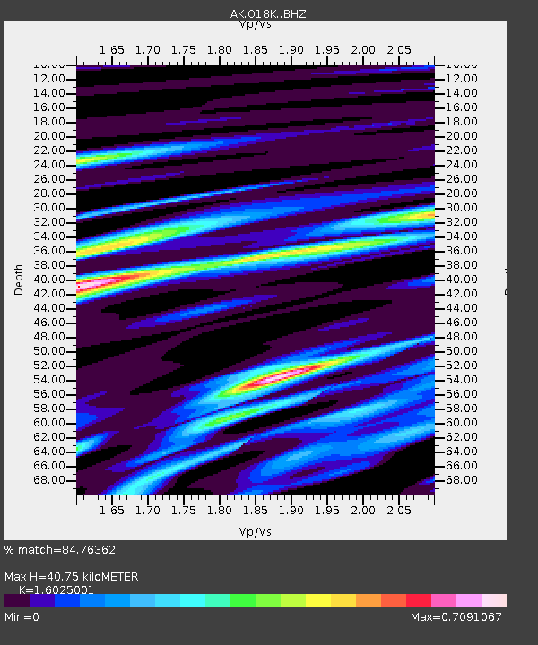
| Estimated Moho Depth: |
40.75 km |
| Estimated Crust Vp/Vs: |
1.60 |
| Assumed Crust Vp: |
6.438 km/s |
| Estimated Crust Vs: |
4.018 km/s |
| Estimated Crust Poisson's Ratio: |
0.18 |
|
| Radial Match: |
84.76362 % |
| Radial Bump: |
400 |
| Transverse Match: |
71.25517 % |
| Transverse Bump: |
400 |
| SOD ConfigId: |
19951751 |
| Insert Time: |
2019-11-18 22:51:28.707 +0000 |
| GWidth: |
2.5 |
| Max Bumps: |
400 |
| Tol: |
0.001 |
|

Signal To Noise
| Channel | StoN | STA | LTA |
| AK:O18K: :BHZ:20191104T22:55:13.179993Z | 7.4036345 | 2.4227297E-6 | 3.272352E-7 |
| AK:O18K: :BHN:20191104T22:55:13.179993Z | 4.5997605 | 1.2822086E-6 | 2.7875552E-7 |
| AK:O18K: :BHE:20191104T22:55:13.179993Z | 0.9275116 | 3.0602214E-7 | 3.2993893E-7 |
| Arrivals |
| Ps | 3.9 SECOND |
| PpPs | 16 SECOND |
| PsPs/PpSs | 20 SECOND |


