You are here: Home > Network List > TS - TERRAscope (Southern California Seismic Network) Stations List
> Station PAS Pasadena, California, USA > Earthquake Result Viewer
PAS Pasadena, California, USA - Earthquake Result Viewer

| Earthquake location: |
Eastern Honshu, Japan |
| Earthquake latitude/longitude: |
39.4/141.1 |
| Earthquake time(UTC): |
2001/12/02 (336) 13:01:53 GMT |
| Earthquake Depth: |
124 km |
| Earthquake Magnitude: |
6.1 MB, 6.5 MW, 6.5 MW |
| Earthquake Catalog/Contributor: |
WHDF/NEIC |
|
| Network: |
TS TERRAscope (Southern California Seismic Network) |
| Station: |
PAS Pasadena, California, USA |
| Lat/Lon: |
34.15 N/118.17 W |
| Elevation: |
295 m |
|
| Distance: |
76.5 deg |
| Az: |
56.927 deg |
| Baz: |
308.476 deg |
| Ray Param: |
0.050658632 |
| Estimated Moho Depth: |
26.75 km |
| Estimated Crust Vp/Vs: |
1.75 |
| Assumed Crust Vp: |
6.1 km/s |
| Estimated Crust Vs: |
3.476 km/s |
| Estimated Crust Poisson's Ratio: |
0.26 |
|
| Radial Match: |
86.71823 % |
| Radial Bump: |
400 |
| Transverse Match: |
83.45072 % |
| Transverse Bump: |
400 |
| SOD ConfigId: |
20082 |
| Insert Time: |
2010-02-26 14:32:58.310 +0000 |
| GWidth: |
2.5 |
| Max Bumps: |
400 |
| Tol: |
0.001 |
|
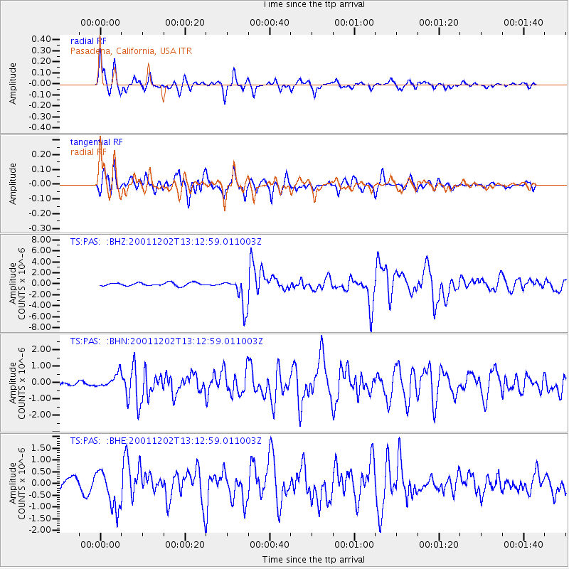
Signal To Noise
| Channel | StoN | STA | LTA |
| TS:PAS: :BHN:20011202T13:12:59.011003Z | 1.6010123 | 4.5918716E-7 | 2.8681052E-7 |
| TS:PAS: :BHE:20011202T13:12:59.011003Z | 4.343938 | 8.490441E-7 | 1.9545493E-7 |
| TS:PAS: :BHZ:20011202T13:12:59.011003Z | 10.481119 | 3.000318E-6 | 2.862593E-7 |
| Arrivals |
| Ps | 3.4 SECOND |
| PpPs | 12 SECOND |
| PsPs/PpSs | 15 SECOND |


