You are here: Home > Network List > CC - Cascade Chain Volcano Monitoring Stations List
> Station SHRK Shell Rock, OR, USA > Earthquake Result Viewer
SHRK Shell Rock, OR, USA - Earthquake Result Viewer
| Earthquake location: |
Tonga Islands |
| Earthquake latitude/longitude: |
-18.4/-175.2 |
| Earthquake time(UTC): |
2019/11/04 (308) 22:43:37 GMT |
| Earthquake Depth: |
10 km |
| Earthquake Magnitude: |
6.9 Mi |
| Earthquake Catalog/Contributor: |
NEIC PDE/at |
|
| Network: |
CC Cascade Chain Volcano Monitoring |
| Station: |
SHRK Shell Rock, OR, USA |
| Lat/Lon: |
45.46 N/121.53 W |
| Elevation: |
1319 m |
|
| Distance: |
80.0 deg |
| Az: |
35.144 deg |
| Baz: |
230.956 deg |
| Ray Param: |
0.048548456 |
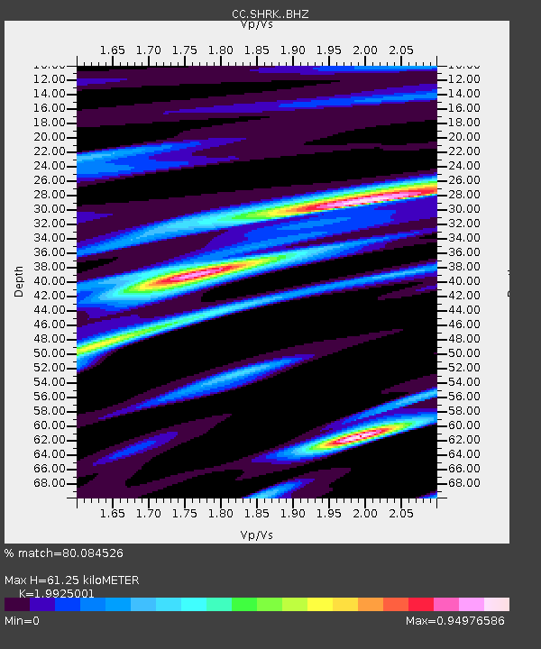
| Estimated Moho Depth: |
61.25 km |
| Estimated Crust Vp/Vs: |
1.99 |
| Assumed Crust Vp: |
6.597 km/s |
| Estimated Crust Vs: |
3.311 km/s |
| Estimated Crust Poisson's Ratio: |
0.33 |
|
| Radial Match: |
80.084526 % |
| Radial Bump: |
400 |
| Transverse Match: |
83.48898 % |
| Transverse Bump: |
400 |
| SOD ConfigId: |
19951751 |
| Insert Time: |
2019-11-18 22:53:42.243 +0000 |
| GWidth: |
2.5 |
| Max Bumps: |
400 |
| Tol: |
0.001 |
|

Signal To Noise
| Channel | StoN | STA | LTA |
| CC:SHRK: :BHZ:20191104T22:55:15.22998Z | 8.299836 | 1.5667824E-6 | 1.8877269E-7 |
| CC:SHRK: :BHN:20191104T22:55:15.22998Z | 2.9245849 | 4.6714794E-7 | 1.5973136E-7 |
| CC:SHRK: :BHE:20191104T22:55:15.22998Z | 1.9506783 | 3.6410736E-7 | 1.8665679E-7 |
| Arrivals |
| Ps | 9.5 SECOND |
| PpPs | 27 SECOND |
| PsPs/PpSs | 37 SECOND |


