You are here: Home > Network List > GS - US Geological Survey Networks Stations List
> Station CA04 CA04, Garlock Fault > Earthquake Result Viewer
CA04 CA04, Garlock Fault - Earthquake Result Viewer
| Earthquake location: |
Tonga Islands |
| Earthquake latitude/longitude: |
-18.4/-175.2 |
| Earthquake time(UTC): |
2019/11/04 (308) 22:43:37 GMT |
| Earthquake Depth: |
10 km |
| Earthquake Magnitude: |
6.9 Mi |
| Earthquake Catalog/Contributor: |
NEIC PDE/at |
|
| Network: |
GS US Geological Survey Networks |
| Station: |
CA04 CA04, Garlock Fault |
| Lat/Lon: |
35.48 N/117.56 W |
| Elevation: |
1005 m |
|
| Distance: |
76.5 deg |
| Az: |
45.155 deg |
| Baz: |
235.573 deg |
| Ray Param: |
0.05095499 |
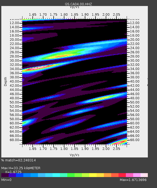
| Estimated Moho Depth: |
33.25 km |
| Estimated Crust Vp/Vs: |
1.67 |
| Assumed Crust Vp: |
6.276 km/s |
| Estimated Crust Vs: |
3.752 km/s |
| Estimated Crust Poisson's Ratio: |
0.22 |
|
| Radial Match: |
82.248314 % |
| Radial Bump: |
400 |
| Transverse Match: |
80.515976 % |
| Transverse Bump: |
400 |
| SOD ConfigId: |
19951751 |
| Insert Time: |
2019-11-18 22:55:29.033 +0000 |
| GWidth: |
2.5 |
| Max Bumps: |
400 |
| Tol: |
0.001 |
|

Signal To Noise
| Channel | StoN | STA | LTA |
| GS:CA04:00:HHZ:20191104T22:54:55.684021Z | 10.187722 | 1.5322512E-6 | 1.5040175E-7 |
| GS:CA04:00:HH1:20191104T22:54:55.684021Z | 2.0943134 | 3.2508012E-7 | 1.5522038E-7 |
| GS:CA04:00:HH2:20191104T22:54:55.684021Z | 3.1661763 | 5.6878315E-7 | 1.7964356E-7 |
| Arrivals |
| Ps | 3.7 SECOND |
| PpPs | 14 SECOND |
| PsPs/PpSs | 17 SECOND |


