You are here: Home > Network List > TS - TERRAscope (Southern California Seismic Network) Stations List
> Station PAS Pasadena, California, USA > Earthquake Result Viewer
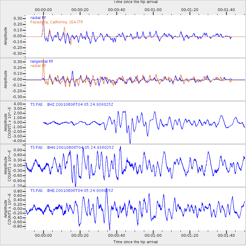
PAS Pasadena, California, USA - Earthquake Result Viewer

| Earthquake location: |
Southern East Pacific Rise |
| Earthquake latitude/longitude: |
-55.5/-123.4 |
| Earthquake time(UTC): |
2001/08/06 (218) 03:52:59 GMT |
| Earthquake Depth: |
10 km |
| Earthquake Magnitude: |
6.1 MB, 6.5 MS, 6.7 MW, 6.2 ME |
| Earthquake Catalog/Contributor: |
WHDF/NEIC |
|
| Network: |
TS TERRAscope (Southern California Seismic Network) |
| Station: |
PAS Pasadena, California, USA |
| Lat/Lon: |
34.15 N/118.17 W |
| Elevation: |
295 m |
|
| Distance: |
89.4 deg |
| Az: |
4.353 deg |
| Baz: |
182.982 deg |
| Ray Param: |
0.0418484 |
| Estimated Moho Depth: |
23.5 km |
| Estimated Crust Vp/Vs: |
1.89 |
| Assumed Crust Vp: |
6.1 km/s |
| Estimated Crust Vs: |
3.223 km/s |
| Estimated Crust Poisson's Ratio: |
0.31 |
|
| Radial Match: |
83.05628 % |
| Radial Bump: |
400 |
| Transverse Match: |
76.08321 % |
| Transverse Bump: |
323 |
| SOD ConfigId: |
20082 |
| Insert Time: |
2010-02-26 14:33:05.538 +0000 |
| GWidth: |
2.5 |
| Max Bumps: |
400 |
| Tol: |
0.001 |
|
Signal To Noise
| Channel | StoN | STA | LTA |
| TS:PAS: :BHN:20010806T04:05:24.936025Z | 0.8338775 | 1.9362055E-7 | 2.3219303E-7 |
| TS:PAS: :BHE:20010806T04:05:24.936025Z | 0.9869306 | 1.2367987E-7 | 1.253177E-7 |
| TS:PAS: :BHZ:20010806T04:05:24.936025Z | 2.6588864 | 5.420368E-7 | 2.0385858E-7 |
| Arrivals |
| Ps | 3.5 SECOND |
| PpPs | 11 SECOND |
| PsPs/PpSs | 14 SECOND |


