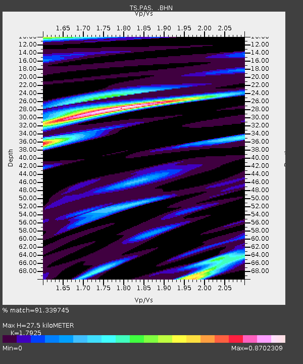
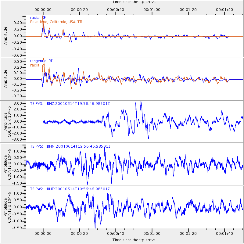
PAS Pasadena, California, USA - Earthquake Result Viewer

Earthquake location: Andreanof Islands, Aleutian Is.
Earthquake latitude/longitude: 51.2/-179.8
Earthquake time(UTC): 2001/06/14 (165) 19:48:47 GMT
Earthquake Depth: 18 km
Earthquake Magnitude: 6.0 MB, 6.3 MS, 6.5 MW, 6.1 ML
Earthquake Catalog/Contributor: WHDF/NEIC
Network: TS TERRAscope (Southern California Seismic Network)
Station: PAS Pasadena, California, USA
Lat/Lon: 34.15 N/118.17 W
Elevation: 295 m
Distance: 47.0 deg
Az: 86.395 deg
Baz: 310.731 deg
Ray Param: 0.07026
Estimated Moho Depth: 27.5 km
Estimated Crust Vp/Vs: 1.79
Assumed Crust Vp: 6.1 km/s
Estimated Crust Vs: 3.403 km/s
Estimated Crust Poisson's Ratio: 0.27
Radial Match: 91.339745 %
Radial Bump: 400
Transverse Match: 75.336235 %
Transverse Bump: 400
SOD ConfigId: 4714
Insert Time: 2010-02-26 14:33:09.054 +0000
GWidth: 2.5
Max Bumps: 400
Tol: 0.001

Signal To Noise

ChannelStoNSTALTA
TS:PAS: :BHN:20010614T19:56:46.98501Z0.93823471.9829402E-72.11348E-7
TS:PAS: :BHE:20010614T19:56:46.98501Z1.23524681.520167E-71.2306585E-7
TS:PAS: :BHZ:20010614T19:56:46.98501Z2.69000124.0922868E-71.5212954E-7
Arrivals
Ps3.8 SECOND
PpPs12 SECOND
PsPs/PpSs16 SECOND