You are here: Home > Network List > TA - USArray Transportable Network (new EarthScope stations) Stations List
> Station G18K Tagagawik, AK, USA > Earthquake Result Viewer
G18K Tagagawik, AK, USA - Earthquake Result Viewer
| Earthquake location: |
Tonga Islands |
| Earthquake latitude/longitude: |
-18.4/-175.2 |
| Earthquake time(UTC): |
2019/11/04 (308) 22:43:37 GMT |
| Earthquake Depth: |
10 km |
| Earthquake Magnitude: |
6.9 Mi |
| Earthquake Catalog/Contributor: |
NEIC PDE/at |
|
| Network: |
TA USArray Transportable Network (new EarthScope stations) |
| Station: |
G18K Tagagawik, AK, USA |
| Lat/Lon: |
65.89 N/158.65 W |
| Elevation: |
484 m |
|
| Distance: |
85.0 deg |
| Az: |
6.743 deg |
| Baz: |
195.751 deg |
| Ray Param: |
0.045103755 |
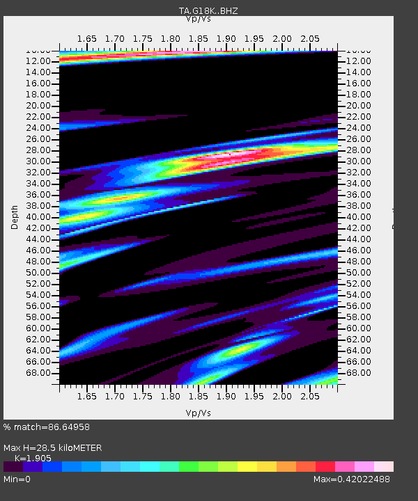
| Estimated Moho Depth: |
28.5 km |
| Estimated Crust Vp/Vs: |
1.90 |
| Assumed Crust Vp: |
6.1 km/s |
| Estimated Crust Vs: |
3.202 km/s |
| Estimated Crust Poisson's Ratio: |
0.31 |
|
| Radial Match: |
86.64958 % |
| Radial Bump: |
400 |
| Transverse Match: |
86.78748 % |
| Transverse Bump: |
400 |
| SOD ConfigId: |
19951751 |
| Insert Time: |
2019-11-18 22:59:12.008 +0000 |
| GWidth: |
2.5 |
| Max Bumps: |
400 |
| Tol: |
0.001 |
|

Signal To Noise
| Channel | StoN | STA | LTA |
| TA:G18K: :BHZ:20191104T22:55:40.825012Z | 3.5534558 | 1.6555737E-6 | 4.6590523E-7 |
| TA:G18K: :BHN:20191104T22:55:40.825012Z | 3.516168 | 5.9433444E-7 | 1.6902901E-7 |
| TA:G18K: :BHE:20191104T22:55:40.825012Z | 1.0536854 | 2.859884E-7 | 2.7141726E-7 |
| Arrivals |
| Ps | 4.3 SECOND |
| PpPs | 13 SECOND |
| PsPs/PpSs | 18 SECOND |


