You are here: Home > Network List > TA - USArray Transportable Network (new EarthScope stations) Stations List
> Station I30M Mount Dempster, Yukon, CAN > Earthquake Result Viewer
I30M Mount Dempster, Yukon, CAN - Earthquake Result Viewer
| Earthquake location: |
Tonga Islands |
| Earthquake latitude/longitude: |
-18.4/-175.2 |
| Earthquake time(UTC): |
2019/11/04 (308) 22:43:37 GMT |
| Earthquake Depth: |
10 km |
| Earthquake Magnitude: |
6.9 Mi |
| Earthquake Catalog/Contributor: |
NEIC PDE/at |
|
| Network: |
TA USArray Transportable Network (new EarthScope stations) |
| Station: |
I30M Mount Dempster, Yukon, CAN |
| Lat/Lon: |
65.22 N/136.38 W |
| Elevation: |
1399 m |
|
| Distance: |
88.4 deg |
| Az: |
15.325 deg |
| Baz: |
216.547 deg |
| Ray Param: |
0.04258492 |
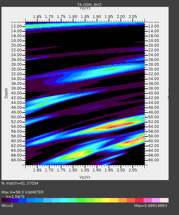
| Estimated Moho Depth: |
59.0 km |
| Estimated Crust Vp/Vs: |
2.07 |
| Assumed Crust Vp: |
6.566 km/s |
| Estimated Crust Vs: |
3.176 km/s |
| Estimated Crust Poisson's Ratio: |
0.35 |
|
| Radial Match: |
81.37054 % |
| Radial Bump: |
400 |
| Transverse Match: |
84.83771 % |
| Transverse Bump: |
400 |
| SOD ConfigId: |
19951751 |
| Insert Time: |
2019-11-18 22:59:24.827 +0000 |
| GWidth: |
2.5 |
| Max Bumps: |
400 |
| Tol: |
0.001 |
|
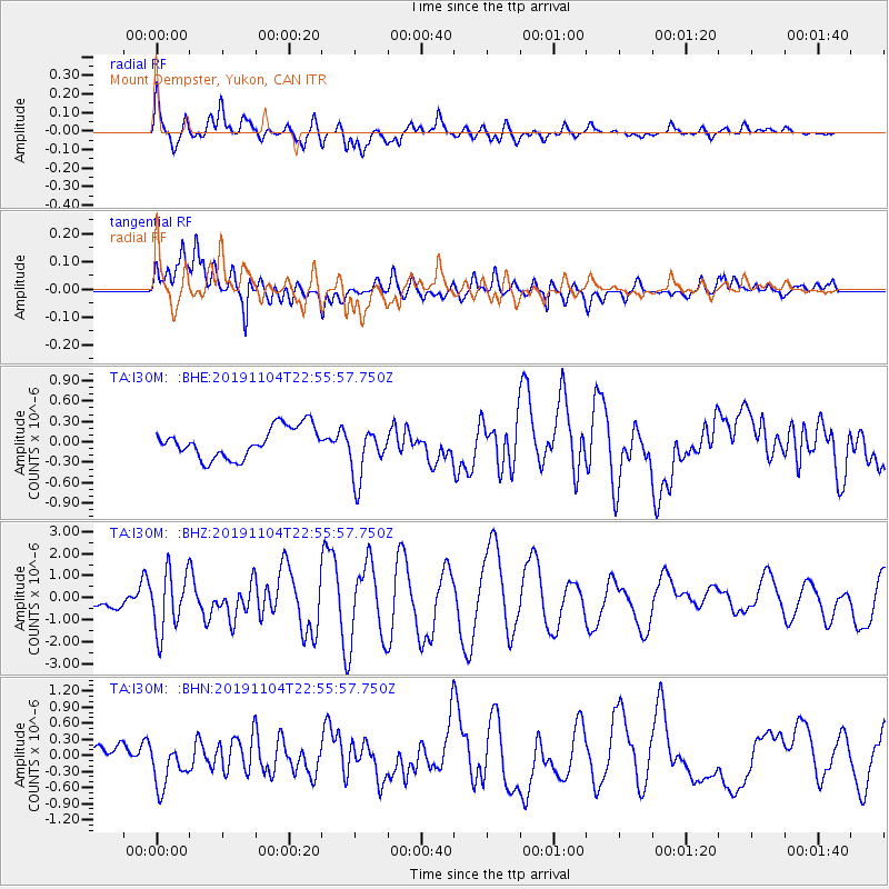
Signal To Noise
| Channel | StoN | STA | LTA |
| TA:I30M: :BHZ:20191104T22:55:57.750Z | 3.790238 | 1.3598333E-6 | 3.5877255E-7 |
| TA:I30M: :BHN:20191104T22:55:57.750Z | 3.3653913 | 4.204641E-7 | 1.2493766E-7 |
| TA:I30M: :BHE:20191104T22:55:57.750Z | 1.726508 | 3.86898E-7 | 2.2409279E-7 |
| Arrivals |
| Ps | 9.8 SECOND |
| PpPs | 27 SECOND |
| PsPs/PpSs | 37 SECOND |


