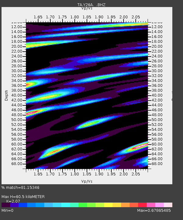
Y26A Elida, NM, USA - Earthquake Result Viewer
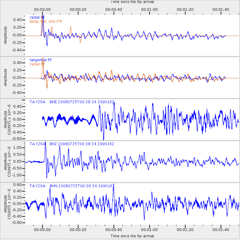
Earthquake location: Rat Islands, Aleutian Islands
Earthquake latitude/longitude: 51.3/179.0
Earthquake time(UTC): 2008/07/25 (207) 00:29:22 GMT
Earthquake Depth: 21 km
Earthquake Magnitude: 5.7 MB, 5.5 MS, 5.9 MW, 5.9 MW
Earthquake Catalog/Contributor: WHDF/NEIC
Network: TA USArray Transportable Network (new EarthScope stations)
Station: Y26A Elida, NM, USA
Lat/Lon: 33.92 N/103.82 W
Elevation: 1371 m
Distance: 56.8 deg
Az: 75.78 deg
Baz: 312.929 deg
Ray Param: 0.063899204
Estimated Moho Depth: 60.5 km
Estimated Crust Vp/Vs: 2.07
Assumed Crust Vp: 6.129 km/s
Estimated Crust Vs: 2.961 km/s
Estimated Crust Poisson's Ratio: 0.35
Radial Match: 81.15346 %
Radial Bump: 400
Transverse Match: 62.99764 %
Transverse Bump: 400
SOD ConfigId: 2504
Insert Time: 2010-03-07 05:34:01.495 +0000
GWidth: 2.5
Max Bumps: 400
Tol: 0.001

Signal To Noise

ChannelStoNSTALTA
TA:Y26A: :BHZ:20080725T00:38:34.399016Z8.4603845.626484E-76.650387E-8
TA:Y26A: :BHN:20080725T00:38:34.399016Z3.59749482.1520717E-75.9821396E-8
TA:Y26A: :BHE:20080725T00:38:34.399016Z3.15779852.5535283E-78.086419E-8
Arrivals
Ps11 SECOND
PpPs29 SECOND
PsPs/PpSs40 SECOND