You are here: Home > Network List > TA - USArray Transportable Network (new EarthScope stations) Stations List
> Station Y26A Elida, NM, USA > Earthquake Result Viewer
Y26A Elida, NM, USA - Earthquake Result Viewer
| Earthquake location: |
North Of Ascension Island |
| Earthquake latitude/longitude: |
-0.2/-17.4 |
| Earthquake time(UTC): |
2008/08/28 (241) 15:22:23 GMT |
| Earthquake Depth: |
15 km |
| Earthquake Magnitude: |
5.8 MB, 5.9 MS, 6.3 MW, 6.3 MW |
| Earthquake Catalog/Contributor: |
WHDF/NEIC |
|
| Network: |
TA USArray Transportable Network (new EarthScope stations) |
| Station: |
Y26A Elida, NM, USA |
| Lat/Lon: |
33.92 N/103.82 W |
| Elevation: |
1371 m |
|
| Distance: |
87.2 deg |
| Az: |
303.806 deg |
| Baz: |
92.169 deg |
| Ray Param: |
0.043485813 |
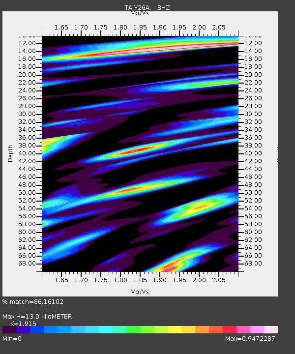
| Estimated Moho Depth: |
13.0 km |
| Estimated Crust Vp/Vs: |
1.91 |
| Assumed Crust Vp: |
6.129 km/s |
| Estimated Crust Vs: |
3.2 km/s |
| Estimated Crust Poisson's Ratio: |
0.31 |
|
| Radial Match: |
86.16102 % |
| Radial Bump: |
400 |
| Transverse Match: |
64.55092 % |
| Transverse Bump: |
400 |
| SOD ConfigId: |
2504 |
| Insert Time: |
2010-03-07 05:34:08.312 +0000 |
| GWidth: |
2.5 |
| Max Bumps: |
400 |
| Tol: |
0.001 |
|
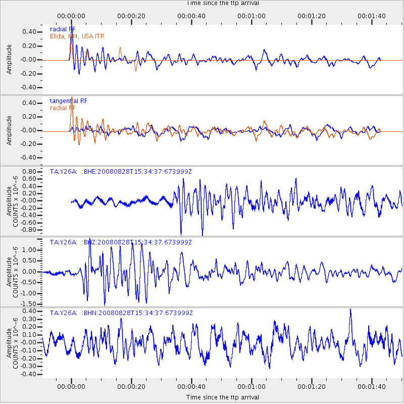
Signal To Noise
| Channel | StoN | STA | LTA |
| TA:Y26A: :BHZ:20080828T15:34:37.673999Z | 4.0313225 | 2.7530123E-7 | 6.8290554E-8 |
| TA:Y26A: :BHN:20080828T15:34:37.673999Z | 1.2294481 | 1.0489961E-7 | 8.532252E-8 |
| TA:Y26A: :BHE:20080828T15:34:37.673999Z | 1.6019039 | 1.0846607E-7 | 6.771072E-8 |
| Arrivals |
| Ps | 2.0 SECOND |
| PpPs | 6.1 SECOND |
| PsPs/PpSs | 8.0 SECOND |


