You are here: Home > Network List > TX - Texas Seismological Network Stations List
> Station PLPT Palo Pinto > Earthquake Result Viewer
PLPT Palo Pinto - Earthquake Result Viewer
| Earthquake location: |
Tonga Islands |
| Earthquake latitude/longitude: |
-18.4/-175.2 |
| Earthquake time(UTC): |
2019/11/04 (308) 22:43:37 GMT |
| Earthquake Depth: |
10 km |
| Earthquake Magnitude: |
6.9 Mi |
| Earthquake Catalog/Contributor: |
NEIC PDE/at |
|
| Network: |
TX Texas Seismological Network |
| Station: |
PLPT Palo Pinto |
| Lat/Lon: |
32.81 N/98.32 W |
| Elevation: |
336 m |
|
| Distance: |
89.3 deg |
| Az: |
55.104 deg |
| Baz: |
247.639 deg |
| Ray Param: |
0.04195121 |
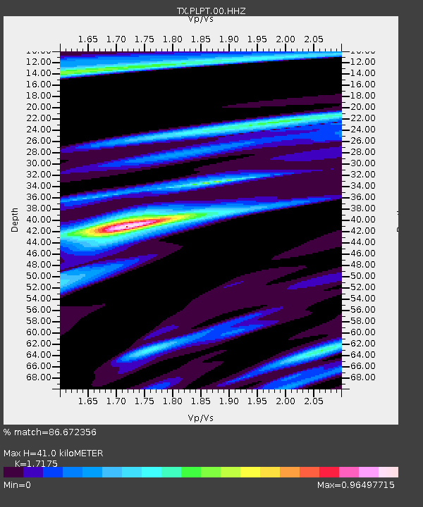
| Estimated Moho Depth: |
41.0 km |
| Estimated Crust Vp/Vs: |
1.72 |
| Assumed Crust Vp: |
6.426 km/s |
| Estimated Crust Vs: |
3.742 km/s |
| Estimated Crust Poisson's Ratio: |
0.24 |
|
| Radial Match: |
86.672356 % |
| Radial Bump: |
269 |
| Transverse Match: |
75.60952 % |
| Transverse Bump: |
281 |
| SOD ConfigId: |
19951751 |
| Insert Time: |
2019-11-18 23:00:44.156 +0000 |
| GWidth: |
2.5 |
| Max Bumps: |
400 |
| Tol: |
0.001 |
|

Signal To Noise
| Channel | StoN | STA | LTA |
| TX:PLPT:00:HHZ:20191104T22:56:01.765015Z | 15.169201 | 1.8754746E-6 | 1.2363701E-7 |
| TX:PLPT:00:HH1:20191104T22:56:01.765015Z | 6.3460083 | 7.1576255E-7 | 1.1278941E-7 |
| TX:PLPT:00:HH2:20191104T22:56:01.765015Z | 1.5989021 | 1.6220274E-7 | 1.01446325E-7 |
| Arrivals |
| Ps | 4.7 SECOND |
| PpPs | 17 SECOND |
| PsPs/PpSs | 22 SECOND |


