You are here: Home > Network List > TX - Texas Seismological Network Stations List
> Station WTFS Witchita Falls > Earthquake Result Viewer
WTFS Witchita Falls - Earthquake Result Viewer
| Earthquake location: |
Tonga Islands |
| Earthquake latitude/longitude: |
-18.4/-175.2 |
| Earthquake time(UTC): |
2019/11/04 (308) 22:43:37 GMT |
| Earthquake Depth: |
10 km |
| Earthquake Magnitude: |
6.9 Mi |
| Earthquake Catalog/Contributor: |
NEIC PDE/at |
|
| Network: |
TX Texas Seismological Network |
| Station: |
WTFS Witchita Falls |
| Lat/Lon: |
33.77 N/98.46 W |
| Elevation: |
277 m |
|
| Distance: |
89.5 deg |
| Az: |
54.177 deg |
| Baz: |
247.549 deg |
| Ray Param: |
0.041770943 |
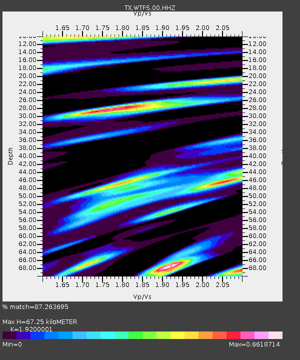
| Estimated Moho Depth: |
67.25 km |
| Estimated Crust Vp/Vs: |
1.92 |
| Assumed Crust Vp: |
6.426 km/s |
| Estimated Crust Vs: |
3.347 km/s |
| Estimated Crust Poisson's Ratio: |
0.31 |
|
| Radial Match: |
87.263695 % |
| Radial Bump: |
341 |
| Transverse Match: |
67.4068 % |
| Transverse Bump: |
393 |
| SOD ConfigId: |
19951751 |
| Insert Time: |
2019-11-18 23:00:50.822 +0000 |
| GWidth: |
2.5 |
| Max Bumps: |
400 |
| Tol: |
0.001 |
|

Signal To Noise
| Channel | StoN | STA | LTA |
| TX:WTFS:00:HHZ:20191104T22:56:02.914978Z | 12.324284 | 1.4866688E-6 | 1.2062922E-7 |
| TX:WTFS:00:HH1:20191104T22:56:02.914978Z | 1.842971 | 4.0759332E-7 | 2.2116102E-7 |
| TX:WTFS:00:HH2:20191104T22:56:02.914978Z | 0.4403462 | 1.0481577E-7 | 2.3803037E-7 |
| Arrivals |
| Ps | 9.8 SECOND |
| PpPs | 30 SECOND |
| PsPs/PpSs | 40 SECOND |


