You are here: Home > Network List > TA - USArray Transportable Network (new EarthScope stations) Stations List
> Station Y26A Elida, NM, USA > Earthquake Result Viewer
Y26A Elida, NM, USA - Earthquake Result Viewer
| Earthquake location: |
Panama-Costa Rica Border Region |
| Earthquake latitude/longitude: |
8.3/-83.0 |
| Earthquake time(UTC): |
2008/11/19 (324) 06:11:20 GMT |
| Earthquake Depth: |
32 km |
| Earthquake Magnitude: |
5.9 MB, 5.9 MS, 6.2 MW, 6.1 MW |
| Earthquake Catalog/Contributor: |
WHDF/NEIC |
|
| Network: |
TA USArray Transportable Network (new EarthScope stations) |
| Station: |
Y26A Elida, NM, USA |
| Lat/Lon: |
33.92 N/103.82 W |
| Elevation: |
1371 m |
|
| Distance: |
32.0 deg |
| Az: |
325.993 deg |
| Baz: |
138.262 deg |
| Ray Param: |
0.0788071 |
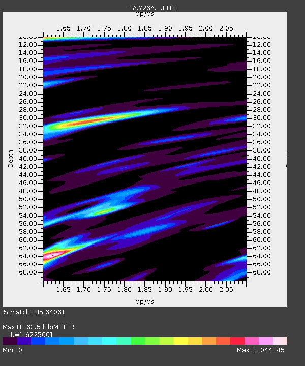
| Estimated Moho Depth: |
63.5 km |
| Estimated Crust Vp/Vs: |
1.62 |
| Assumed Crust Vp: |
6.129 km/s |
| Estimated Crust Vs: |
3.777 km/s |
| Estimated Crust Poisson's Ratio: |
0.19 |
|
| Radial Match: |
85.64061 % |
| Radial Bump: |
319 |
| Transverse Match: |
56.865276 % |
| Transverse Bump: |
400 |
| SOD ConfigId: |
2658 |
| Insert Time: |
2010-03-07 05:34:22.735 +0000 |
| GWidth: |
2.5 |
| Max Bumps: |
400 |
| Tol: |
0.001 |
|
Signal To Noise
| Channel | StoN | STA | LTA |
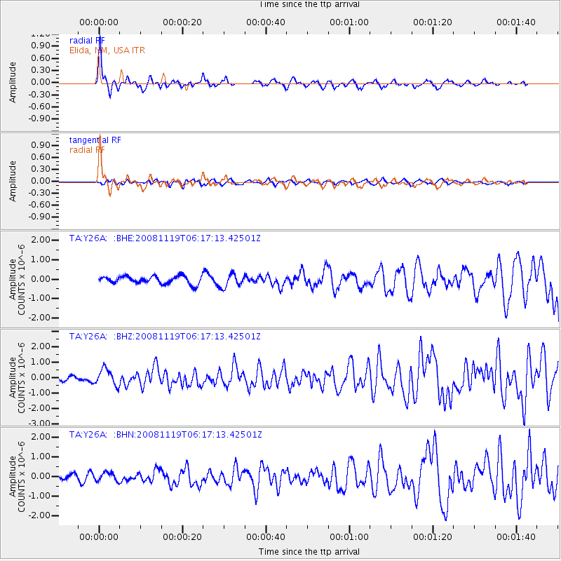
| TA:Y26A: :BHZ:20081119T06:17:13.42501Z | 2.2790062 | 5.4138445E-7 | 2.3755287E-7 |
| TA:Y26A: :BHN:20081119T06:17:13.42501Z | 1.242791 | 2.2749326E-7 | 1.8305029E-7 |
| TA:Y26A: :BHE:20081119T06:17:13.42501Z | 1.7021317 | 3.380887E-7 | 1.9862664E-7 |
| Arrivals |
| Ps | 7.0 SECOND |
| PpPs | 25 SECOND |
| PsPs/PpSs | 32 SECOND |


