You are here: Home > Network List > TA - USArray Transportable Network (new EarthScope stations) Stations List
> Station Y26A Elida, NM, USA > Earthquake Result Viewer
Y26A Elida, NM, USA - Earthquake Result Viewer

| Earthquake location: |
Near S. Coast Of Honshu, Japan |
| Earthquake latitude/longitude: |
33.2/137.9 |
| Earthquake time(UTC): |
2009/08/09 (221) 10:55:55 GMT |
| Earthquake Depth: |
297 km |
| Earthquake Magnitude: |
6.5 MB, 7.1 MW, 7.1 MW |
| Earthquake Catalog/Contributor: |
WHDF/NEIC |
|
| Network: |
TA USArray Transportable Network (new EarthScope stations) |
| Station: |
Y26A Elida, NM, USA |
| Lat/Lon: |
33.92 N/103.82 W |
| Elevation: |
1371 m |
|
| Distance: |
91.6 deg |
| Az: |
47.127 deg |
| Baz: |
312.333 deg |
| Ray Param: |
0.041438337 |
| Estimated Moho Depth: |
36.75 km |
| Estimated Crust Vp/Vs: |
1.83 |
| Assumed Crust Vp: |
6.129 km/s |
| Estimated Crust Vs: |
3.345 km/s |
| Estimated Crust Poisson's Ratio: |
0.29 |
|
| Radial Match: |
87.603966 % |
| Radial Bump: |
400 |
| Transverse Match: |
77.91785 % |
| Transverse Bump: |
400 |
| SOD ConfigId: |
2622 |
| Insert Time: |
2010-03-07 05:34:24.553 +0000 |
| GWidth: |
2.5 |
| Max Bumps: |
400 |
| Tol: |
0.001 |
|
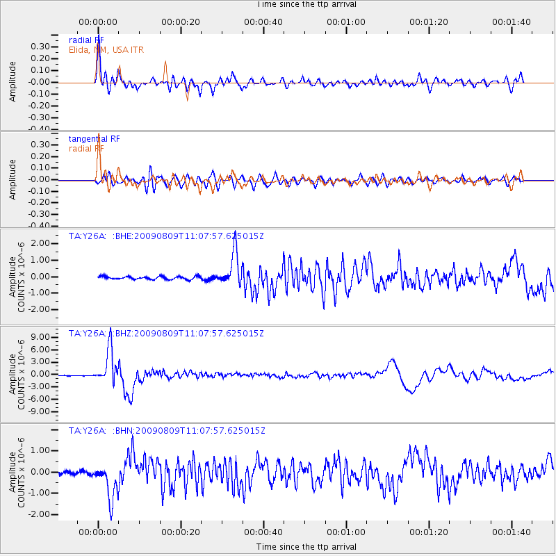
Signal To Noise
| Channel | StoN | STA | LTA |
| TA:Y26A: :BHZ:20090809T11:07:57.625015Z | 51.56287 | 4.285717E-6 | 8.311634E-8 |
| TA:Y26A: :BHN:20090809T11:07:57.625015Z | 10.293813 | 8.703819E-7 | 8.455389E-8 |
| TA:Y26A: :BHE:20090809T11:07:57.625015Z | 11.877783 | 1.0523112E-6 | 8.8594916E-8 |
| Arrivals |
| Ps | 5.1 SECOND |
| PpPs | 17 SECOND |
| PsPs/PpSs | 22 SECOND |


