You are here: Home > Network List > UU - University of Utah Regional Network Stations List
> Station MTPU Mt. Pierson, UT, USA > Earthquake Result Viewer
MTPU Mt. Pierson, UT, USA - Earthquake Result Viewer
| Earthquake location: |
Tonga Islands |
| Earthquake latitude/longitude: |
-18.4/-175.2 |
| Earthquake time(UTC): |
2019/11/04 (308) 22:43:37 GMT |
| Earthquake Depth: |
10 km |
| Earthquake Magnitude: |
6.9 Mi |
| Earthquake Catalog/Contributor: |
NEIC PDE/at |
|
| Network: |
UU University of Utah Regional Network |
| Station: |
MTPU Mt. Pierson, UT, USA |
| Lat/Lon: |
38.04 N/112.18 W |
| Elevation: |
3112 m |
|
| Distance: |
81.5 deg |
| Az: |
45.349 deg |
| Baz: |
238.816 deg |
| Ray Param: |
0.04753617 |
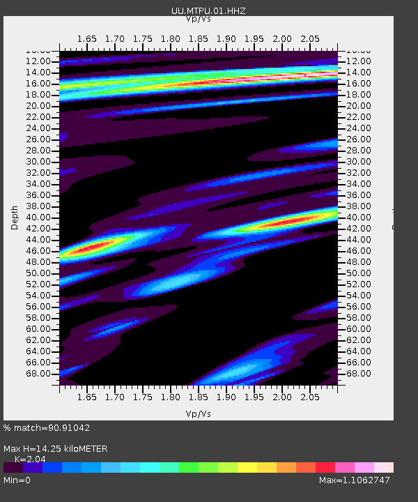
| Estimated Moho Depth: |
14.25 km |
| Estimated Crust Vp/Vs: |
2.04 |
| Assumed Crust Vp: |
6.276 km/s |
| Estimated Crust Vs: |
3.076 km/s |
| Estimated Crust Poisson's Ratio: |
0.34 |
|
| Radial Match: |
90.91042 % |
| Radial Bump: |
322 |
| Transverse Match: |
83.02092 % |
| Transverse Bump: |
400 |
| SOD ConfigId: |
19951751 |
| Insert Time: |
2019-11-18 23:01:44.599 +0000 |
| GWidth: |
2.5 |
| Max Bumps: |
400 |
| Tol: |
0.001 |
|

Signal To Noise
| Channel | StoN | STA | LTA |
| UU:MTPU:01:HHZ:20191104T22:55:23.057983Z | 7.4657497 | 5.7266575E-8 | 7.670573E-9 |
| UU:MTPU:01:HHN:20191104T22:55:23.057983Z | 0.57054627 | 4.54036E-9 | 7.957917E-9 |
| UU:MTPU:01:HHE:20191104T22:55:23.057983Z | 3.6172943 | 1.9938886E-8 | 5.512099E-9 |
| Arrivals |
| Ps | 2.4 SECOND |
| PpPs | 6.7 SECOND |
| PsPs/PpSs | 9.2 SECOND |


