You are here: Home > Network List > TS - TERRAscope (Southern California Seismic Network) Stations List
> Station PAS Pasadena, California, USA > Earthquake Result Viewer
PAS Pasadena, California, USA - Earthquake Result Viewer
| Earthquake location: |
El Salvador |
| Earthquake latitude/longitude: |
13.0/-88.7 |
| Earthquake time(UTC): |
2001/01/13 (013) 17:33:32 GMT |
| Earthquake Depth: |
60 km |
| Earthquake Magnitude: |
6.4 MB, 7.8 MS, 7.7 MW, 7.5 ME |
| Earthquake Catalog/Contributor: |
WHDF/NEIC |
|
| Network: |
TS TERRAscope (Southern California Seismic Network) |
| Station: |
PAS Pasadena, California, USA |
| Lat/Lon: |
34.15 N/118.17 W |
| Elevation: |
295 m |
|
| Distance: |
34.0 deg |
| Az: |
313.122 deg |
| Baz: |
120.944 deg |
| Ray Param: |
0.07778972 |
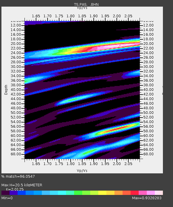
| Estimated Moho Depth: |
20.5 km |
| Estimated Crust Vp/Vs: |
2.01 |
| Assumed Crust Vp: |
6.1 km/s |
| Estimated Crust Vs: |
3.031 km/s |
| Estimated Crust Poisson's Ratio: |
0.34 |
|
| Radial Match: |
96.0547 % |
| Radial Bump: |
400 |
| Transverse Match: |
85.6933 % |
| Transverse Bump: |
400 |
| SOD ConfigId: |
3744 |
| Insert Time: |
2010-02-26 14:33:16.082 +0000 |
| GWidth: |
2.5 |
| Max Bumps: |
400 |
| Tol: |
0.001 |
|

Signal To Noise
| Channel | StoN | STA | LTA |
| TS:PAS: :BHN:20010113T17:39:40.433986Z | 0.78753364 | 5.185284E-7 | 6.584207E-7 |
| TS:PAS: :BHE:20010113T17:39:40.433986Z | 2.6329558 | 1.0159722E-6 | 3.8586757E-7 |
| TS:PAS: :BHZ:20010113T17:39:40.433986Z | 4.466851 | 2.8998663E-6 | 6.4919703E-7 |
| Arrivals |
| Ps | 3.6 SECOND |
| PpPs | 9.5 SECOND |
| PsPs/PpSs | 13 SECOND |


