You are here: Home > Network List > UW - Pacific Northwest Regional Seismic Network Stations List
> Station GBB GBB, Hanford, WA, USA > Earthquake Result Viewer
GBB GBB, Hanford, WA, USA - Earthquake Result Viewer
| Earthquake location: |
Tonga Islands |
| Earthquake latitude/longitude: |
-18.4/-175.2 |
| Earthquake time(UTC): |
2019/11/04 (308) 22:43:37 GMT |
| Earthquake Depth: |
10 km |
| Earthquake Magnitude: |
6.9 Mi |
| Earthquake Catalog/Contributor: |
NEIC PDE/at |
|
| Network: |
UW Pacific Northwest Regional Seismic Network |
| Station: |
GBB GBB, Hanford, WA, USA |
| Lat/Lon: |
46.61 N/119.63 W |
| Elevation: |
185 m |
|
| Distance: |
81.8 deg |
| Az: |
35.067 deg |
| Baz: |
232.307 deg |
| Ray Param: |
0.04734055 |
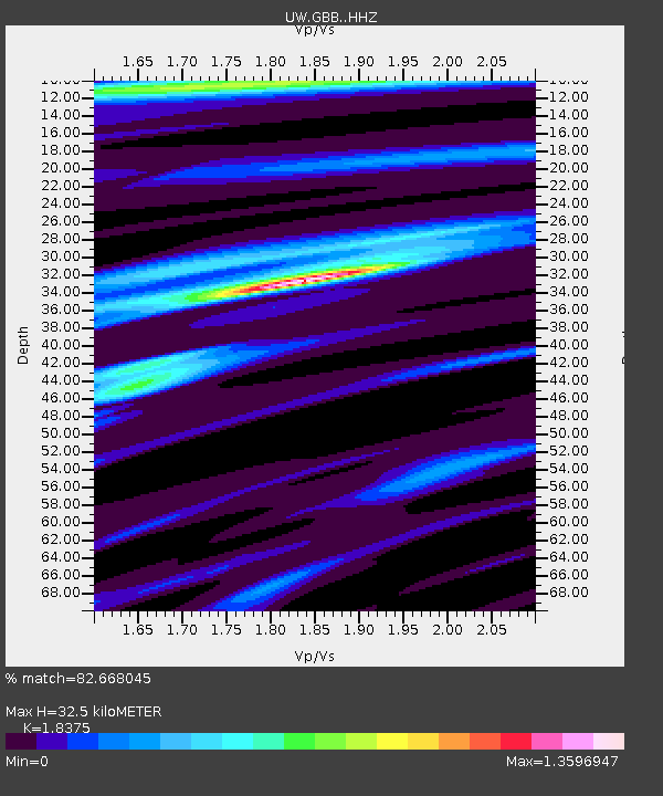
| Estimated Moho Depth: |
32.5 km |
| Estimated Crust Vp/Vs: |
1.84 |
| Assumed Crust Vp: |
6.419 km/s |
| Estimated Crust Vs: |
3.493 km/s |
| Estimated Crust Poisson's Ratio: |
0.29 |
|
| Radial Match: |
82.668045 % |
| Radial Bump: |
400 |
| Transverse Match: |
68.9573 % |
| Transverse Bump: |
400 |
| SOD ConfigId: |
19951751 |
| Insert Time: |
2019-11-18 23:01:58.637 +0000 |
| GWidth: |
2.5 |
| Max Bumps: |
400 |
| Tol: |
0.001 |
|

Signal To Noise
| Channel | StoN | STA | LTA |
| UW:GBB: :HHZ:20191104T22:55:24.530029Z | 8.345101 | 1.4283102E-6 | 1.7115552E-7 |
| UW:GBB: :HHN:20191104T22:55:24.530029Z | 2.266103 | 3.262127E-7 | 1.4395317E-7 |
| UW:GBB: :HHE:20191104T22:55:24.530029Z | 2.4128482 | 3.766773E-7 | 1.5611313E-7 |
| Arrivals |
| Ps | 4.4 SECOND |
| PpPs | 14 SECOND |
| PsPs/PpSs | 18 SECOND |


